
- Forum
- Drakensberg Forum
- Drakensberg Grand Traverse
- Grand Traverse Write-ups
- The upside-down Dragon: GT2012
The upside-down Dragon: GT2012
10 May 2012 07:08 #53811
by ghaznavid
Replied by ghaznavid on topic Re: The upside-down Dragon: GT2012
I was hoping to get the last installment up today, but I am on training this afternoon, so I will aim for tomorrow. Sorry guys 
Please Log in or Create an account to join the conversation.

10 May 2012 07:42 - 10 May 2012 07:46 #53815
by Bigsnake
Replied by Bigsnake on topic Re: The upside-down Dragon: GT2012
Really enjoying the saga ghaznavid.
Setting new standards of reportage.
Many thanks for your efforts
Setting new standards of reportage.
Many thanks for your efforts
Last edit: 10 May 2012 07:46 by Bigsnake.
Please Log in or Create an account to join the conversation.

10 May 2012 15:29 #53821
by Boerkie
Replied by Boerkie on topic Re: The upside-down Dragon: GT2012
Ghaz a.k.a ex-popple a.k.a the dragon slayer a.k.a Wilber Smith
Thx buddy
Thx buddy
Please Log in or Create an account to join the conversation.

11 May 2012 11:50 #53831
by Clark
Replied by Clark on topic Re: The upside-down Dragon: GT2012
Ghaz, you talk of your qualifying hikes for doing the GT. What does this entail?
Please Log in or Create an account to join the conversation.
11 May 2012 13:29 #53832
by ghaznavid
Replied by ghaznavid on topic Re: The upside-down Dragon: GT2012
Day 9: Mnweni at last(Tseketseke to Senqu Valley)
The resupply team is planning on descending Cockade Pass, so the first kilometre of the day will be done by the combined group. John decided that we should get some extra time to sleep this morning, so the planned departure time is 7:30 as opposed to the customary 6:30 for 6:45. It’s funny how you slowly get into a rhythm. For the first few days you scramble to get ready on time, but day 9 you are eating a bowl of porridge at 6:15 before you have even properly woken up. By 7 all the GT members are packed and ready to go, most of the Resuppliers haven’t even started taking their tents down yet! Then again, we have been practicing this for days.We set off to a beautiful sunrise, the Elephant eying us with a golden glow.
Today will be the day that I finally get to enter the Mnweni area of the Drakensberg. After all I have read and all the photos I have seen, this area has a lot to live up to. We say goodbye to the resupply team at the top of Cockade Pass and we begin the not particularly difficult climb up the Elephant ridge. As we approach the top of the ridge it becomes apparent where the name of the peak comes from.
I hear comment “the resupply guys can’t see us anymore, right? Good, we can start walking slowly again!” I think to myself how ironic it is that for some reason we walked faster than normal this morning. Pride is a funny thing, I guess subconsciously we all wanted to look like we were still fresh and energetic after our many days of walking. Really we were more energetic this morning than usual, but our enthusiasm would soon return to its normal levels.
On top of the ridge, metres from the summit of a khulu – 3202m on the watershed, we stop for a break. John asks the group if we all agree that we should arrange to camp at Witsieshoek on Tuesday night, and we all agree. We take a half an hour break and John makes the necessary calls. While this is happening, Tony and myself climb the peak. We both thought it was the illusive Mahout, but on inspection of the map and the khulu list it appeared that it is not.After completing the GT we discovered that this peak is in fact Mahout.
The Tseketseke Valley as seen from Mahout
Yesterday, Peter – the leader of the resupply team – told me that in his experience the ridges on the last few days of a grand traverse all just kind of melt together and you really don’t remember them. I begin to realise that he is right. Fortunately, armed with my camera, so my memory can easily be refreshed!
We drop into the valley behind the Elephant. Tony and myself debate which gully is the top of Xeni Pass. We don’t stop to look at a map. It’s amazing how the first few days of a GT include so much urgency and you don’t stop often or for very long. By day 9 you are through all the long days, and the Northern Berg is much easier to traverse than the Southern and Central Berg, no big long ridges, not many deep gullies, and much more ridge walking. The pace of the group is definitely down, and we are stopping for numerous long breaks. We come across two groups of hikers this morning. The one group is very friendly, they tell us of their three day trek from the Chain Ladders to the Bell Traverse – well they tell us that this is their plan. The second group shouts something from the other side of the river, but we can’t hear what they are saying.
We bump into a large group of hikers just before lunch
We keep walking for a kilometre or two, and then stop for yet another break by the river. I trade some cashews for some of Ruan’sprovitas. He offers the group marmite and we all realise that he has been carrying a good half a kilogram marmite since the start of the hike. We all enjoy the process of helping him reduce the weight of his pack!
We continue walking, John points out Easter Cave Peak to me, that means we are more or less behind the Cathedral range right now. Some good photos should be coming on the next ridge. The Mnweni Saddle comes into view in the distance. Our original hiking plan listed the base of the North Peak as our camping spot for tonight, so despite our many breaks we are in fact making good progress.
As we begin the ascent of the next ridge the north view of the Cathedral range comes into view, it looks so different, but as always, once the Inner and Outer Horn come into view, the identity of the range is given away.
The ridge is fairly long, but not very steep, but just as you think you have reached the top, you realise that there is still a long way to go. We reach the rock band and traverse away from the escarpment edge, looking for a gap in the rock. We eventually reach a rocky ramp which we ascend to find some more ridge in need of climbing. As the top of the ridge gets closer, in the distance the Cathkin range comes into view. This could only mean one thing, this is actually a fairly high ridge.
John asks if we would like to take a break here and the group declines, upward and onward we must go. We reach the top of the ridge and bump into yet another group of hikers. You can tell that it is a 5 day weekend for those who taking the Monday off as leave! We stop at the top of this ridge for a lunch break. Its only 12:30 and yet we are within an hour range of our planned stop for the day. Although we all know that we must continue on from where we planned to stop if we wish to finish a day early.
The view from this spot includes Swinburne, Harismith and Van Reenen’s Pass, not to mention the northern regions of KwaZulu-Natal.
We set off into the great Mnweni. As we descend into the valley behind North Peak, Ruan spots two Reedbok. They run away before my camera manages to capture them. We follow the fairly gentle drop into the valley and reach the spot at which we planned to camp for the night. John asks if we are all willing to go on, and no objection is heard. I think to myself how it would be nice to camp here, bag some khulus and get an early day, but I must not hold the group back, after all, I too want to finish early.
We cross the river and begin the ascent of the North Peak ridge. The ridge is high, steep and long. This is the first time in a while that a ridge has actually been difficult, but the ridge is not nearly as difficult as the ones in the south. The top is eventually reached. The summit rewards us with a view of Rockeries and Mponjwane. There are vultures flying in the distant valley that hold Rockeries Pass.
We descend into the Senqu Valley and find a suitable spot on the river. This is the source of the Orange River. The water levels are low and filling water bottles is slow, but otherwise it is a good spot for camping. We enjoy supper under a clear [freezing cold] starry sky.
Day 10:That looks easy (Senqu Valley to Icidi)
We set off to a clear morning – first stop for the day will be a lookout point over the Hanging Valley. The first minor ridge for the morning melts away without much difficulty and before I know it there is an amazing view of the Mnweni valley, and more importantly, the Hanging Valley. I recognise Manxome Pass in the distance and suddenly I have the Jabberwock poem ringing in my head, “He took the Vorpal sword in hand, long time the MANXOME foe he sought, he rested by the Tumtum tree and stood a while in thought”.
The hanging valley, a small part of Manxome pass can be seen behind the ridge on the right
There are lots of unclimbed pinnacles in this area, many easy rock climbs with no cairns on top, but it’s doubtful that it would be worth a rock climbers while to climb many of these small detached bits of former-escarpment when there are majestic pinnacles, needles and towers all around.
The Mnweni area has been carved more prominently by wind erosion than water erosion – a fact that can be clearly seen by the way the land is shaped;this is the cause of such rugged beauty. I get lots of photos each time we stop, this area is different indeed!
As we summit the following ridge that eye-sore of a mine comes into view. That kind of takes away from the “untouched beauty” label given to this region by most hikers. We follow the ridge for a while. The view into South Africa is amazing, the eye-sore in Lesotho is best ignored! The heads of the Mnweni Pinnacles are just visible over the top of the ridge.
We drop over the ridge and stop for a short break at the top of Pins Pass. We all realise that we are now so close to the end that the easiest “pull-out” route is down the chain ladders. Baring some serious injury, we should all get to the end. Andre has been coming down with a throat infection for the last few days, fortunately his perseverance and prayer is paying off – the infection is getting better.
We continue our trek behind the ridge that holds the summit to Rwanqa Pass and the Black and Tan Wall. The ridge is largely uneventful – after such a dramatic start to the hike, the last few days have been largely uneventful.
We continue to the top of Fangs Pass. We stop for a brief break looking at the view of the Donkey. We all know the end is close, there is a fine balance between fatigue from what we have done so far, but excitement for the completion of the hike.
We continue for a short distance, a visit to Rat Hole Cave is made. The cave proves to be larger than I expected. A short distance later we reach the view of Madonna and her Worshipers. We stop here for lunch. I “help Ruan lighten his pack” by trading some more nuts for provitas and marmite. The lunch stop is pleasant, no real wind, clear sunlight. Tony manages to complete his quest of finding Skylight Cave, but the stop is otherwise uneventful.
We continue around the Mbundini Abbey. We begin the climb up the not-very-difficult Stimela Ridge. A view of Mponjwane and the “real Mponjwane” next to each other comes into view, fortunately my camera with its 18X zoom is up for the task. As we summit the ridge the Icidi Ridge comes into view. The end is really in sight.
Left to right: Cathedral Peak, The Bell, Mponjwane, North Saddle and the Cathkin Range
John points out that we are now in comfortable striking range of the finish line – any spot that is suitable can be our camping spot for the day. It is still fairly early in the day and we have no real reason to stop, by day 10 of a GT you are so much fitter than you were on day 1, but this is combined with fatigue and aches from the reason that you are fitter!
As we drop into the valley we see some baboons, hopefully they won’t be giving us trouble later today. We follow the ridge as closely as possible to avoid losing altitude, but before we know it we are ascending the ridge that extends from the Icidi Buttress. As we reach the top of the ridge I notice the massive gully in the valley – this valley drains into South Africa, that is unusual indeed.
We drop down into the valley that includes the Icidi Back Ridge, Icidi Crown, Icidi Cap and the Icidi Buttress. The river is very low and there is no suitable spot near the river. We continue up the northern bank and drop just over the watershed, a nice flat spot is found.
After setting up, Tony, John, Ruan and myself head up to check out Icidi Cave. The cave is easy to find and well sheltered, but the roof is very low and there is not much space. John heads back to camp, while the rest of us head up the Icidi Crown. As we pass a gully we get a clear view down to the Icidi Pencil. Tony and I discuss how it is remarkable how well John Hone has survived with Leukaemia, not many people survive two blood transfusions.At the time of writing, the bitter irony of this timing is now apparent, such as sad loss to the hiking community – at least he is no longer suffering with this painful disease.
The Icidi Pencil, a rock climb that earned a full chapter of John Hone's book "Encounters with the Dragon"
We continue the climb to the summit of this khulu. The name – the Icidi CROWN is very appropriate. The view from the summit is amazing. We can see the entire Northern Drakensberg from the Cathkin Range, Cathedral Range, the Mnweni Saddle, Rockeries, Mnweni Needles and much more.
The wind on the summit is strong, we start descending the peak. I discuss climbing the Icidi Cap, but no one else is interested. I decide to climb it anyway. Access to the summit requires a small amount of rock scrambling, but the large flat summit is easily reached. The view of Icidi Pass from the peak makes the climb worth it, but the view doesn’t match the view from the Icidi Crown. On the way down I find a route through the rock band without any rock scrambling.
I reach camp as the sun sets behind the Icidi Back Ridge.I borrow a wind shield to cook some food, the wind is strong and my stove is difficult to light, but it soon gets going. As I take my soup off the stove I discover that the wind has caused my stove to heat my handle more than the soup, I spill a third of my soup trying to avoid my hand getting significantly burned. Fortunately the burns aren’t bad and it’s late enough in the hike for this not to cause any major issue.
Day 11: All good things come to an end(Icidi to Witsieshoek)
My alarm clock goes off, and without thinking about it I achieve a status of being ready and packed. I get some photos of the red sunrise. It’s amazing how you are completely in a rhythm by the end, even Neil who usually makes us wait is ready before the planned departure time. We joke about not leaving till 7AM. We end up leaving at 6:58.
John tells us that we have 2 options, walk around all the ridges for the day, get to the Sentinal car park early but forfeit the views, alternatively we can follow the escarpment edge and enjoy the view. We all agree that the escarpment edge is a good idea. We head over the nearby ridge and drop into the valley near it only to realise that we could have walked around it and got the same view.
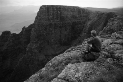
We begin the ascent up the Ifidi Ridge, I leave the group so that I can climb Ifidi Peak. The view from the summit is incredible. As I begin to descend only to see John indicating that I am about to reach a high rock face, I turn around and climb down the side I came up. But wait, where is the group?
The view looking north from just below Ifidi Peak
I begin to drop down on the Lesotho side of the ridge, but I don’t see anyone from the group. I walk to the ledge on top of the ridge and still don’t see anyone on either side. The strong wind blowing into Lesotho makes the prospect of shouting to try to locate the team a pointless idea – even if they can hear me I still won’t be able to hear them call back. I continue to drop down the ridge.
About half way down I begin to get concerned – not that I won’t find them or that I may be lost, it wouldn’t take a rocket scientist to work out the route to the end from here. I decide to try the other side of the ridge once more. I hear my name shouted by someone, there they are, sitting behind a rock band far up the ridge. No wonder I didn’t see them!
John, Tony, Neil, Andre and Ruan have gone in search of the many caves above Ifidi Pass, the rest of the group comes down towards the altitude at which I am standing. I meat up with the group near the escarpment edge. “Don’t go wondering off like that, we thought you were lost” Jo shouts at me, I try to explain that I couldn’t see them hiding behind the rock band, but she will hear none of it. Admittedly not the response I was expecting! On the bright side the group was going to be waiting for the other guys anyway, so no actual harm was done.
They guys return one by one after finding Ifidi Cave and False Ifidi Cave. Ruan heads towards the Singati Wall ahead of the group to buy some time to take photos of the Tooth and Eastern Buttress. I decide to follow suite, the weather is decent for photos. The group will smell the end soon, so our pace is unlikely to be this slow for long.
I look over the ridge and realise that I really do not know the peaks in from of me that well, and the old Singsby map is of little use in determining what I am looking at. I know the Eastern Buttress, the Tooth, the Inner Tower, no sign of a Toothpick and I don’t know which peak is Mount Amery or the Singati Wall. All I know is that according to the MCSA khulu list of 1994, the Singati Wall is a rock climbing khulu, not one accessible from the escarpment.
After admiring the view for a bit I head off towards the saddle between the 3160m unnamed peak that is most likely a khulu and what is probably Mount Amery. On reaching the saddle I leave my pack with the three ladies and Ruan (who beat me to the saddle), and attempt a final khulu for the GT. As I begin to climb I realise that there is a large gully half way up this ridge, I backtrack and climb up around it. I find myself just below the knife edge of the ridge only to see a roughly 100m deep gully between me and the summit itself. Is this the Singati Wall I wonder, but no, there is a way around. I look back to see the entire group waiting. Maybe I should leave this one for next time. I head down. Subsequently I reviewed the map and I now believe that I was looking at the correct peak.
As we walk down the ridge I notice a large prominent peak on the Amphitheatre edge, there is no name for it on the map and no spot height that I notice on the map. I later figured out that this prominent tower is 3019 on the Singsby map (I am yet to buy an Amphitheatre EKZN map), this must be Amphitheatre Peak.
We continue high on the ridge overlooking the back of the Drakensberg’s most famous rock wall. The view is good, but not as impressive as what we have seen in the past few days. We begin to descend onto the flat plains on the summit of this prominent region. In my mind I liken the region to the plains of Gorgoroth – flat, rocky and basically no vegetation (and right near the end of a very long story). In the distance the Crow’s Nest and Mont-Aux-Sources are now clearly visible.
As we reach a lookout spot I get to see something I have wanted to see for years - Tugela Falls from the escarpment. I first saw this majestic statistically significant waterfall was on 24 December 2004. The falls were heavily overflowing and it was a beautiful clear day. This time I looked at it and remarked “wow, there’s the second highest damp rock face in the world”. It took a while to figure out where the falls where supposed to be.
We stop for a break by the falls. John phones the Witsieshoek Resort and arranges transport from the Sentinel Car Park to the resort. We will be picked up at 1:30, that gives us 2 hours to reach the finish line.
We continue over the ridge near the falls. A troop of baboons run away as we pass nearby. We then descend into the Tugela valley. We briefly pause at the hut, just long enough to get some photos of the fairly shoddy looking hut – not as bad as I expected though. We keep moving towards the chain ladders.
I think to myself how I originally got into hiking partially with a goal of getting over my fear of heights. The chain ladders will be a real test of how well this ploy has worked.
We slowly ascend up the path which is almost wide enough for a car, this route is clearly as heavily used as they say. Today is 1 May, a public holiday, a fact of which we are reminded by the huge volume of people who don’t even have backpacks on. I think to myself how easily the weather turns in the place and how easily these “hikers” could end up in real danger, no water bottles, no food, just shorts and a T-shirt in late autumn.
As we drop over the ridge I get a good view of the Free State Drakensberg. In front of me there is a massive cairn which promptly gets that little bit bigger as I add my stone to it. And then I see the top of the chain ladders. The drop off on the side of the mountain makes them seem higher than they actually are. We have a brief discussion as to whether or not this constitutes a pass, I conclude it does, some of the other members of the group agree to disagree.
I stop to put my trekking pole and camera away before my descent. I wait a few minutes and then I go to the far chain ladder to begin the descent off the escarpment that has been my home for the last 11 days. I look down, that’s not far at all. I start the by no means vertical descent. I feel my pack shifting as I take my first step.
With each slow step the slope gets steeper until it is eventually vertical. Initially I was able to put my entire foot into the rung, enough that the groove of my shoe could make my stance very stable, but now only the front of my shoe fits it. The rings on the ladder no longer hold it far enough away from the rock and every step I take the entire ladder shifts.
I reach the bottom of the first stage. I know the lower section is longer. I probably should not look down, but how can you reach the far ladder without doing this. The far ladder is a mission to reach, the slope is steep and the surface is slippery. I reach it facing forward. Once I have the top of the ladder to hold onto I manage to turn around and get a proper grip on it. Each time I look to see a foothold I see the bottom and remember just how far down it is. I feel like I have been on this ladder for a while. The group is waiting for me at the bottom.
After what felt like a good half an hour – although apparently it was no longer than ten minutes – I reach the bottom. In a short distance I will have done it, a complete South to North Grand Traverse. I joke with the guys that I have had enough of this; I want to turn back and walk to Bushman’s Nek! You know that the other members of the group are tired when you just get a strange look at a comment like this, either that or they may just be tired of my sense of humour.
We begin the walk to the Sentinel Car Park. I look at the mighty Sentinel. What an impressive lump of rock it is. As we walk along we pass the Sentinel Caves, Beacon Buttress Gulley and I scramble up the ledge between the Sentinel and the Buttress to get a view of the Amphitheatre. What a view!
We continue along, stopping for lunch just below the Sentinel. This is a quick stop, we only have half an hour to reach the car park. We continue down the Zigzags, past some tourists who think it’s a wise idea to climb the Chain Ladders after midday with no supplies whatsoever, not even water bottles.
We then reach the section below the Witches. John gets a call asking if we are almost there, our transport is running late – perfect, more time for photos. I have long since given up on the dream of 3000 photos, but I must make sure I reach 2000 at a minimum. But, as always, I will not take photos just for the sake of taking photos. Near the car park I visit yet another lookout point – the Amphitheatre is definitely more impressive looking up than it is from the top.
We reach the Sentinel Car Park – the end is here at last. Now 4 of us are about to get into the car for which we are all paying a total of R150– this for an 8km trip (talk about abuse of a monopoly), the other 5 will walk, although all packs will go in the car. I am not looking forward to walking on a road.
We all shake hands and congratulate each other on the completion of this tough quest – a goal I had set for myself while still in primary school now accomplished.
One of the guys comes over and tells us that a person who is about to drive back can drop us off just short of resort. Relieved, 5 of us jump into the back of the bakkie. It’s a long drive and we are happy not to be walking it. The driver apparently changes his mind about not stopping at Witsieshoek, and takes us right up to the front door. The gesture is greatly appreciated by us and we offer to pay for his drinks, he declines.
Nine hikers at Witsieshoek
We all get together for the group shots. Lorinda (who had left her car at Witsieshoek in order to avoid driving back to Karkloof and then reversing the route on her way home) says goodbye and heads off home. The rest of us set up our tents, enjoy a nice hot shower and get some food.
A large burger and chips followed up by a fillet steak and chips seems to be the appropriate way to celebrate the completion of a very long and eventful hike – not to mention my three plates of breakfast the next morning…
Final stats
Distance walked: 250km
Altitude gained: 10km
Total photos: 2011 (and 2 videos)
Totals khulus bagged: 11
Total kgologos bagged: 2 (Mafadi included)
Time taken: 10 days 6 hours and 2 minutes – maybe a South to North speed record")
Weight lost (after eating the ridiculous amounts of food listed above): 12kgs
Will I do it again: that’s a stupid question!
The resupply team is planning on descending Cockade Pass, so the first kilometre of the day will be done by the combined group. John decided that we should get some extra time to sleep this morning, so the planned departure time is 7:30 as opposed to the customary 6:30 for 6:45. It’s funny how you slowly get into a rhythm. For the first few days you scramble to get ready on time, but day 9 you are eating a bowl of porridge at 6:15 before you have even properly woken up. By 7 all the GT members are packed and ready to go, most of the Resuppliers haven’t even started taking their tents down yet! Then again, we have been practicing this for days.We set off to a beautiful sunrise, the Elephant eying us with a golden glow.
Today will be the day that I finally get to enter the Mnweni area of the Drakensberg. After all I have read and all the photos I have seen, this area has a lot to live up to. We say goodbye to the resupply team at the top of Cockade Pass and we begin the not particularly difficult climb up the Elephant ridge. As we approach the top of the ridge it becomes apparent where the name of the peak comes from.
I hear comment “the resupply guys can’t see us anymore, right? Good, we can start walking slowly again!” I think to myself how ironic it is that for some reason we walked faster than normal this morning. Pride is a funny thing, I guess subconsciously we all wanted to look like we were still fresh and energetic after our many days of walking. Really we were more energetic this morning than usual, but our enthusiasm would soon return to its normal levels.
On top of the ridge, metres from the summit of a khulu – 3202m on the watershed, we stop for a break. John asks the group if we all agree that we should arrange to camp at Witsieshoek on Tuesday night, and we all agree. We take a half an hour break and John makes the necessary calls. While this is happening, Tony and myself climb the peak. We both thought it was the illusive Mahout, but on inspection of the map and the khulu list it appeared that it is not.After completing the GT we discovered that this peak is in fact Mahout.
The Tseketseke Valley as seen from Mahout
Yesterday, Peter – the leader of the resupply team – told me that in his experience the ridges on the last few days of a grand traverse all just kind of melt together and you really don’t remember them. I begin to realise that he is right. Fortunately, armed with my camera, so my memory can easily be refreshed!
We drop into the valley behind the Elephant. Tony and myself debate which gully is the top of Xeni Pass. We don’t stop to look at a map. It’s amazing how the first few days of a GT include so much urgency and you don’t stop often or for very long. By day 9 you are through all the long days, and the Northern Berg is much easier to traverse than the Southern and Central Berg, no big long ridges, not many deep gullies, and much more ridge walking. The pace of the group is definitely down, and we are stopping for numerous long breaks. We come across two groups of hikers this morning. The one group is very friendly, they tell us of their three day trek from the Chain Ladders to the Bell Traverse – well they tell us that this is their plan. The second group shouts something from the other side of the river, but we can’t hear what they are saying.
We bump into a large group of hikers just before lunch
We keep walking for a kilometre or two, and then stop for yet another break by the river. I trade some cashews for some of Ruan’sprovitas. He offers the group marmite and we all realise that he has been carrying a good half a kilogram marmite since the start of the hike. We all enjoy the process of helping him reduce the weight of his pack!
We continue walking, John points out Easter Cave Peak to me, that means we are more or less behind the Cathedral range right now. Some good photos should be coming on the next ridge. The Mnweni Saddle comes into view in the distance. Our original hiking plan listed the base of the North Peak as our camping spot for tonight, so despite our many breaks we are in fact making good progress.
As we begin the ascent of the next ridge the north view of the Cathedral range comes into view, it looks so different, but as always, once the Inner and Outer Horn come into view, the identity of the range is given away.
The ridge is fairly long, but not very steep, but just as you think you have reached the top, you realise that there is still a long way to go. We reach the rock band and traverse away from the escarpment edge, looking for a gap in the rock. We eventually reach a rocky ramp which we ascend to find some more ridge in need of climbing. As the top of the ridge gets closer, in the distance the Cathkin range comes into view. This could only mean one thing, this is actually a fairly high ridge.
John asks if we would like to take a break here and the group declines, upward and onward we must go. We reach the top of the ridge and bump into yet another group of hikers. You can tell that it is a 5 day weekend for those who taking the Monday off as leave! We stop at the top of this ridge for a lunch break. Its only 12:30 and yet we are within an hour range of our planned stop for the day. Although we all know that we must continue on from where we planned to stop if we wish to finish a day early.
The view from this spot includes Swinburne, Harismith and Van Reenen’s Pass, not to mention the northern regions of KwaZulu-Natal.
We set off into the great Mnweni. As we descend into the valley behind North Peak, Ruan spots two Reedbok. They run away before my camera manages to capture them. We follow the fairly gentle drop into the valley and reach the spot at which we planned to camp for the night. John asks if we are all willing to go on, and no objection is heard. I think to myself how it would be nice to camp here, bag some khulus and get an early day, but I must not hold the group back, after all, I too want to finish early.
We cross the river and begin the ascent of the North Peak ridge. The ridge is high, steep and long. This is the first time in a while that a ridge has actually been difficult, but the ridge is not nearly as difficult as the ones in the south. The top is eventually reached. The summit rewards us with a view of Rockeries and Mponjwane. There are vultures flying in the distant valley that hold Rockeries Pass.
We descend into the Senqu Valley and find a suitable spot on the river. This is the source of the Orange River. The water levels are low and filling water bottles is slow, but otherwise it is a good spot for camping. We enjoy supper under a clear [freezing cold] starry sky.
Day 10:That looks easy (Senqu Valley to Icidi)
We set off to a clear morning – first stop for the day will be a lookout point over the Hanging Valley. The first minor ridge for the morning melts away without much difficulty and before I know it there is an amazing view of the Mnweni valley, and more importantly, the Hanging Valley. I recognise Manxome Pass in the distance and suddenly I have the Jabberwock poem ringing in my head, “He took the Vorpal sword in hand, long time the MANXOME foe he sought, he rested by the Tumtum tree and stood a while in thought”.
The hanging valley, a small part of Manxome pass can be seen behind the ridge on the right
There are lots of unclimbed pinnacles in this area, many easy rock climbs with no cairns on top, but it’s doubtful that it would be worth a rock climbers while to climb many of these small detached bits of former-escarpment when there are majestic pinnacles, needles and towers all around.
The Mnweni area has been carved more prominently by wind erosion than water erosion – a fact that can be clearly seen by the way the land is shaped;this is the cause of such rugged beauty. I get lots of photos each time we stop, this area is different indeed!
As we summit the following ridge that eye-sore of a mine comes into view. That kind of takes away from the “untouched beauty” label given to this region by most hikers. We follow the ridge for a while. The view into South Africa is amazing, the eye-sore in Lesotho is best ignored! The heads of the Mnweni Pinnacles are just visible over the top of the ridge.
We drop over the ridge and stop for a short break at the top of Pins Pass. We all realise that we are now so close to the end that the easiest “pull-out” route is down the chain ladders. Baring some serious injury, we should all get to the end. Andre has been coming down with a throat infection for the last few days, fortunately his perseverance and prayer is paying off – the infection is getting better.
We continue our trek behind the ridge that holds the summit to Rwanqa Pass and the Black and Tan Wall. The ridge is largely uneventful – after such a dramatic start to the hike, the last few days have been largely uneventful.
We continue to the top of Fangs Pass. We stop for a brief break looking at the view of the Donkey. We all know the end is close, there is a fine balance between fatigue from what we have done so far, but excitement for the completion of the hike.
We continue for a short distance, a visit to Rat Hole Cave is made. The cave proves to be larger than I expected. A short distance later we reach the view of Madonna and her Worshipers. We stop here for lunch. I “help Ruan lighten his pack” by trading some more nuts for provitas and marmite. The lunch stop is pleasant, no real wind, clear sunlight. Tony manages to complete his quest of finding Skylight Cave, but the stop is otherwise uneventful.
We continue around the Mbundini Abbey. We begin the climb up the not-very-difficult Stimela Ridge. A view of Mponjwane and the “real Mponjwane” next to each other comes into view, fortunately my camera with its 18X zoom is up for the task. As we summit the ridge the Icidi Ridge comes into view. The end is really in sight.
Left to right: Cathedral Peak, The Bell, Mponjwane, North Saddle and the Cathkin Range
John points out that we are now in comfortable striking range of the finish line – any spot that is suitable can be our camping spot for the day. It is still fairly early in the day and we have no real reason to stop, by day 10 of a GT you are so much fitter than you were on day 1, but this is combined with fatigue and aches from the reason that you are fitter!
As we drop into the valley we see some baboons, hopefully they won’t be giving us trouble later today. We follow the ridge as closely as possible to avoid losing altitude, but before we know it we are ascending the ridge that extends from the Icidi Buttress. As we reach the top of the ridge I notice the massive gully in the valley – this valley drains into South Africa, that is unusual indeed.
We drop down into the valley that includes the Icidi Back Ridge, Icidi Crown, Icidi Cap and the Icidi Buttress. The river is very low and there is no suitable spot near the river. We continue up the northern bank and drop just over the watershed, a nice flat spot is found.
After setting up, Tony, John, Ruan and myself head up to check out Icidi Cave. The cave is easy to find and well sheltered, but the roof is very low and there is not much space. John heads back to camp, while the rest of us head up the Icidi Crown. As we pass a gully we get a clear view down to the Icidi Pencil. Tony and I discuss how it is remarkable how well John Hone has survived with Leukaemia, not many people survive two blood transfusions.At the time of writing, the bitter irony of this timing is now apparent, such as sad loss to the hiking community – at least he is no longer suffering with this painful disease.
The Icidi Pencil, a rock climb that earned a full chapter of John Hone's book "Encounters with the Dragon"
We continue the climb to the summit of this khulu. The name – the Icidi CROWN is very appropriate. The view from the summit is amazing. We can see the entire Northern Drakensberg from the Cathkin Range, Cathedral Range, the Mnweni Saddle, Rockeries, Mnweni Needles and much more.
The wind on the summit is strong, we start descending the peak. I discuss climbing the Icidi Cap, but no one else is interested. I decide to climb it anyway. Access to the summit requires a small amount of rock scrambling, but the large flat summit is easily reached. The view of Icidi Pass from the peak makes the climb worth it, but the view doesn’t match the view from the Icidi Crown. On the way down I find a route through the rock band without any rock scrambling.
I reach camp as the sun sets behind the Icidi Back Ridge.I borrow a wind shield to cook some food, the wind is strong and my stove is difficult to light, but it soon gets going. As I take my soup off the stove I discover that the wind has caused my stove to heat my handle more than the soup, I spill a third of my soup trying to avoid my hand getting significantly burned. Fortunately the burns aren’t bad and it’s late enough in the hike for this not to cause any major issue.
Day 11: All good things come to an end(Icidi to Witsieshoek)
My alarm clock goes off, and without thinking about it I achieve a status of being ready and packed. I get some photos of the red sunrise. It’s amazing how you are completely in a rhythm by the end, even Neil who usually makes us wait is ready before the planned departure time. We joke about not leaving till 7AM. We end up leaving at 6:58.
John tells us that we have 2 options, walk around all the ridges for the day, get to the Sentinal car park early but forfeit the views, alternatively we can follow the escarpment edge and enjoy the view. We all agree that the escarpment edge is a good idea. We head over the nearby ridge and drop into the valley near it only to realise that we could have walked around it and got the same view.
We begin the ascent up the Ifidi Ridge, I leave the group so that I can climb Ifidi Peak. The view from the summit is incredible. As I begin to descend only to see John indicating that I am about to reach a high rock face, I turn around and climb down the side I came up. But wait, where is the group?
The view looking north from just below Ifidi Peak
I begin to drop down on the Lesotho side of the ridge, but I don’t see anyone from the group. I walk to the ledge on top of the ridge and still don’t see anyone on either side. The strong wind blowing into Lesotho makes the prospect of shouting to try to locate the team a pointless idea – even if they can hear me I still won’t be able to hear them call back. I continue to drop down the ridge.
About half way down I begin to get concerned – not that I won’t find them or that I may be lost, it wouldn’t take a rocket scientist to work out the route to the end from here. I decide to try the other side of the ridge once more. I hear my name shouted by someone, there they are, sitting behind a rock band far up the ridge. No wonder I didn’t see them!
John, Tony, Neil, Andre and Ruan have gone in search of the many caves above Ifidi Pass, the rest of the group comes down towards the altitude at which I am standing. I meat up with the group near the escarpment edge. “Don’t go wondering off like that, we thought you were lost” Jo shouts at me, I try to explain that I couldn’t see them hiding behind the rock band, but she will hear none of it. Admittedly not the response I was expecting! On the bright side the group was going to be waiting for the other guys anyway, so no actual harm was done.
They guys return one by one after finding Ifidi Cave and False Ifidi Cave. Ruan heads towards the Singati Wall ahead of the group to buy some time to take photos of the Tooth and Eastern Buttress. I decide to follow suite, the weather is decent for photos. The group will smell the end soon, so our pace is unlikely to be this slow for long.
I look over the ridge and realise that I really do not know the peaks in from of me that well, and the old Singsby map is of little use in determining what I am looking at. I know the Eastern Buttress, the Tooth, the Inner Tower, no sign of a Toothpick and I don’t know which peak is Mount Amery or the Singati Wall. All I know is that according to the MCSA khulu list of 1994, the Singati Wall is a rock climbing khulu, not one accessible from the escarpment.
After admiring the view for a bit I head off towards the saddle between the 3160m unnamed peak that is most likely a khulu and what is probably Mount Amery. On reaching the saddle I leave my pack with the three ladies and Ruan (who beat me to the saddle), and attempt a final khulu for the GT. As I begin to climb I realise that there is a large gully half way up this ridge, I backtrack and climb up around it. I find myself just below the knife edge of the ridge only to see a roughly 100m deep gully between me and the summit itself. Is this the Singati Wall I wonder, but no, there is a way around. I look back to see the entire group waiting. Maybe I should leave this one for next time. I head down. Subsequently I reviewed the map and I now believe that I was looking at the correct peak.
As we walk down the ridge I notice a large prominent peak on the Amphitheatre edge, there is no name for it on the map and no spot height that I notice on the map. I later figured out that this prominent tower is 3019 on the Singsby map (I am yet to buy an Amphitheatre EKZN map), this must be Amphitheatre Peak.
We continue high on the ridge overlooking the back of the Drakensberg’s most famous rock wall. The view is good, but not as impressive as what we have seen in the past few days. We begin to descend onto the flat plains on the summit of this prominent region. In my mind I liken the region to the plains of Gorgoroth – flat, rocky and basically no vegetation (and right near the end of a very long story). In the distance the Crow’s Nest and Mont-Aux-Sources are now clearly visible.
As we reach a lookout spot I get to see something I have wanted to see for years - Tugela Falls from the escarpment. I first saw this majestic statistically significant waterfall was on 24 December 2004. The falls were heavily overflowing and it was a beautiful clear day. This time I looked at it and remarked “wow, there’s the second highest damp rock face in the world”. It took a while to figure out where the falls where supposed to be.
We stop for a break by the falls. John phones the Witsieshoek Resort and arranges transport from the Sentinel Car Park to the resort. We will be picked up at 1:30, that gives us 2 hours to reach the finish line.
We continue over the ridge near the falls. A troop of baboons run away as we pass nearby. We then descend into the Tugela valley. We briefly pause at the hut, just long enough to get some photos of the fairly shoddy looking hut – not as bad as I expected though. We keep moving towards the chain ladders.
I think to myself how I originally got into hiking partially with a goal of getting over my fear of heights. The chain ladders will be a real test of how well this ploy has worked.
We slowly ascend up the path which is almost wide enough for a car, this route is clearly as heavily used as they say. Today is 1 May, a public holiday, a fact of which we are reminded by the huge volume of people who don’t even have backpacks on. I think to myself how easily the weather turns in the place and how easily these “hikers” could end up in real danger, no water bottles, no food, just shorts and a T-shirt in late autumn.
As we drop over the ridge I get a good view of the Free State Drakensberg. In front of me there is a massive cairn which promptly gets that little bit bigger as I add my stone to it. And then I see the top of the chain ladders. The drop off on the side of the mountain makes them seem higher than they actually are. We have a brief discussion as to whether or not this constitutes a pass, I conclude it does, some of the other members of the group agree to disagree.
I stop to put my trekking pole and camera away before my descent. I wait a few minutes and then I go to the far chain ladder to begin the descent off the escarpment that has been my home for the last 11 days. I look down, that’s not far at all. I start the by no means vertical descent. I feel my pack shifting as I take my first step.
With each slow step the slope gets steeper until it is eventually vertical. Initially I was able to put my entire foot into the rung, enough that the groove of my shoe could make my stance very stable, but now only the front of my shoe fits it. The rings on the ladder no longer hold it far enough away from the rock and every step I take the entire ladder shifts.
I reach the bottom of the first stage. I know the lower section is longer. I probably should not look down, but how can you reach the far ladder without doing this. The far ladder is a mission to reach, the slope is steep and the surface is slippery. I reach it facing forward. Once I have the top of the ladder to hold onto I manage to turn around and get a proper grip on it. Each time I look to see a foothold I see the bottom and remember just how far down it is. I feel like I have been on this ladder for a while. The group is waiting for me at the bottom.
After what felt like a good half an hour – although apparently it was no longer than ten minutes – I reach the bottom. In a short distance I will have done it, a complete South to North Grand Traverse. I joke with the guys that I have had enough of this; I want to turn back and walk to Bushman’s Nek! You know that the other members of the group are tired when you just get a strange look at a comment like this, either that or they may just be tired of my sense of humour.
We begin the walk to the Sentinel Car Park. I look at the mighty Sentinel. What an impressive lump of rock it is. As we walk along we pass the Sentinel Caves, Beacon Buttress Gulley and I scramble up the ledge between the Sentinel and the Buttress to get a view of the Amphitheatre. What a view!
We continue along, stopping for lunch just below the Sentinel. This is a quick stop, we only have half an hour to reach the car park. We continue down the Zigzags, past some tourists who think it’s a wise idea to climb the Chain Ladders after midday with no supplies whatsoever, not even water bottles.
We then reach the section below the Witches. John gets a call asking if we are almost there, our transport is running late – perfect, more time for photos. I have long since given up on the dream of 3000 photos, but I must make sure I reach 2000 at a minimum. But, as always, I will not take photos just for the sake of taking photos. Near the car park I visit yet another lookout point – the Amphitheatre is definitely more impressive looking up than it is from the top.
We reach the Sentinel Car Park – the end is here at last. Now 4 of us are about to get into the car for which we are all paying a total of R150– this for an 8km trip (talk about abuse of a monopoly), the other 5 will walk, although all packs will go in the car. I am not looking forward to walking on a road.
We all shake hands and congratulate each other on the completion of this tough quest – a goal I had set for myself while still in primary school now accomplished.
One of the guys comes over and tells us that a person who is about to drive back can drop us off just short of resort. Relieved, 5 of us jump into the back of the bakkie. It’s a long drive and we are happy not to be walking it. The driver apparently changes his mind about not stopping at Witsieshoek, and takes us right up to the front door. The gesture is greatly appreciated by us and we offer to pay for his drinks, he declines.
Nine hikers at Witsieshoek
We all get together for the group shots. Lorinda (who had left her car at Witsieshoek in order to avoid driving back to Karkloof and then reversing the route on her way home) says goodbye and heads off home. The rest of us set up our tents, enjoy a nice hot shower and get some food.
A large burger and chips followed up by a fillet steak and chips seems to be the appropriate way to celebrate the completion of a very long and eventful hike – not to mention my three plates of breakfast the next morning…
Final stats
Distance walked: 250km
Altitude gained: 10km
Total photos: 2011 (and 2 videos)
Totals khulus bagged: 11
Total kgologos bagged: 2 (Mafadi included)
Time taken: 10 days 6 hours and 2 minutes – maybe a South to North speed record
Weight lost (after eating the ridiculous amounts of food listed above): 12kgs
Will I do it again: that’s a stupid question!
Please login or register to view the images attached to this post.
The following user(s) said Thank You: diverian, Stijn, plouw, Bigsnake, brio, LouisvV, Smurfatefrog, tonymarshall, Wizman, RogerRood, vanhimself
Please Log in or Create an account to join the conversation.
11 May 2012 18:47 #53833
by Smurfatefrog
Replied by Smurfatefrog on topic Re: The upside-down Dragon: GT2012
Thanks Ghaz, really enjoyed that. Congrats to you, Tony & co!
Please Log in or Create an account to join the conversation.
- Smurfatefrog
-

- Offline
- Moderator
-

Less
More
- Posts: 1132
- Thank you received: 1550
14 May 2012 01:20 #53839
by Serious tribe
Replied by Serious tribe on topic Re: The upside-down Dragon: GT2012
Sweet Ghaz. Gr8 story. Now i don't even have to do it, I felt every step you took.
Please Log in or Create an account to join the conversation.
- Serious tribe
-

- Offline
- Platinum Member
-

Less
More
- Posts: 1056
- Thank you received: 770
14 May 2012 05:27 #53842
by intrepid
Take nothing but litter, leave nothing but a cleaner Drakensberg.
Replied by intrepid on topic Re: The upside-down Dragon: GT2012
Thanks Ghaz for a fun write-up! Gongrats to you and your team for completing it.
Take nothing but litter, leave nothing but a cleaner Drakensberg.
Please Log in or Create an account to join the conversation.

14 May 2012 15:32 #53869
by brio
Replied by brio on topic Re: The upside-down Dragon: GT2012
Ditto on the well done, to all.
Please Log in or Create an account to join the conversation.

15 May 2012 19:02 #53890
by Sterkhorn
Replied by Sterkhorn on topic Re: The upside-down Dragon: GT2012
Congratulations Ghaznavid on completing the Traverse and thanks for the interesting report.
We observed your group from near the Tugela Falls as you approached the Amphitheatre wall, and we were ascending towards the top of Beacon Butress as you passed on your way towards the Chain Ladder at about 12 noon on the 1st May.
We observed your group from near the Tugela Falls as you approached the Amphitheatre wall, and we were ascending towards the top of Beacon Butress as you passed on your way towards the Chain Ladder at about 12 noon on the 1st May.
Please Log in or Create an account to join the conversation.

