
Rainbow Gorge
19 Nov 2017 13:37 - 19 Nov 2017 13:38 #72385
by ibrahim
Rainbow Gorge was created by ibrahim
i have walked the sentinel previously.
however I will be now accompanied by my family.
so I am looking for a fairly easy hiking trail.
I did some reading and found Rainbow Gorge to be a suitable hike, in terms of distance and scenery.
any advise in this walk (length and time) or other recommendations.
however I will be now accompanied by my family.
so I am looking for a fairly easy hiking trail.
I did some reading and found Rainbow Gorge to be a suitable hike, in terms of distance and scenery.
any advise in this walk (length and time) or other recommendations.
Last edit: 19 Nov 2017 13:38 by ibrahim. Reason: spelling
Please Log in or Create an account to join the conversation.
19 Nov 2017 19:34 #72387
by biomech
Replied by biomech on topic Rainbow Gorge
Rainbow gorge is great for kids, but can turn into a 8km hike if you go quite far up. Tugela gorge is also great. We found the walk to Pillar Cave at Garden Castle to also be great.
Please Log in or Create an account to join the conversation.
26 Nov 2017 10:17 #72409
by ibrahim
Replied by ibrahim on topic Rainbow Gorge
thanks for the reply.
from where did you begin the hike for rainbow gorge.
how long is the hike. (distance)
from where did you begin the hike for rainbow gorge.
how long is the hike. (distance)
Please Log in or Create an account to join the conversation.
27 Nov 2017 13:09 #72413
by Rhinoandhedgehog
Replied by Rhinoandhedgehog on topic Rainbow Gorge
try this
Rainbow Gorge Trail Link
you dont have to do tryme hill but it is nice little add-on
this is also very pleasent
Sleeping Beauty Trail Link
Rainbow Gorge Trail Link
you dont have to do tryme hill but it is nice little add-on
this is also very pleasent
Sleeping Beauty Trail Link
Please Log in or Create an account to join the conversation.
- Rhinoandhedgehog
-
- Offline
- Premium Member
-

Less
More
- Posts: 95
- Thank you received: 56
19 Dec 2017 08:22 #72502
by tonymarshall
Replied by tonymarshall on topic Rainbow Gorge
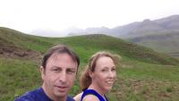
In April Mia, my wife, and I did the Rainbow Gorge day hike at Didima, about an 8½ km round trip if you go as far as the section where the gorge narrows with the chockstone. There has been some recent interest in Rainbow Gorge on the forum, so here are some photos and brief notes on the Rainbow Gorge hike.
The hike starts at the Didima offices and car park, and follows the concrete path up the lower section of Tryme Hill past the Didima Conference Centre.
Before reaching the rock band on Tryme Hill, the path to Rainbow Gorge turns off the main path to the left.
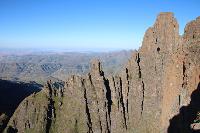
The path contours beneath the rock band for a while, turning a corner high above the river. In the photo below, the road of Mikes Pass is at the left, the escarpment view to Little Saddle and Windsor Castle is in the centre, and Rainbow Gorge is the river fork to the right.
The path descends gradually into the gorge, entering the natural forest before reaching the river, and you are then surrounded by the forest and the sound of waterfalls and running water.
Two short wooden ladders assist hikers up steeper sections of the path.
A view up a flatter section of the stream in the gorge.
We took a short break, before tackling the upper section of Rainbow Gorge.
Another steep section has some chains to make the going easier.
The hike starts at the Didima offices and car park, and follows the concrete path up the lower section of Tryme Hill past the Didima Conference Centre.
Before reaching the rock band on Tryme Hill, the path to Rainbow Gorge turns off the main path to the left.
The path contours beneath the rock band for a while, turning a corner high above the river. In the photo below, the road of Mikes Pass is at the left, the escarpment view to Little Saddle and Windsor Castle is in the centre, and Rainbow Gorge is the river fork to the right.
The path descends gradually into the gorge, entering the natural forest before reaching the river, and you are then surrounded by the forest and the sound of waterfalls and running water.
Two short wooden ladders assist hikers up steeper sections of the path.
A view up a flatter section of the stream in the gorge.
We took a short break, before tackling the upper section of Rainbow Gorge.
Another steep section has some chains to make the going easier.
Please login or register to view the images attached to this post.
The following user(s) said Thank You: Andreas, Christinejvr
Please Log in or Create an account to join the conversation.
- tonymarshall
-

- Offline
- VE Advisory
-

Less
More
- Posts: 770
- Thank you received: 2244
19 Dec 2017 08:27 #72504
by tonymarshall
Replied by tonymarshall on topic Rainbow Gorge
After climbing up above the river, the path stays above the river through a steeper section of the gorge.
In places the path goes between large boulders.
All around the waterfalls and forest make for a wonderful setting and atmosphere.
Up until now, the gorge path had been on the right (true left) of the river heading upstream, but as you near the narrowing of the gorge and chockstone, the path crosses back and forth across the river, and in places you walk in the water.
At the narrowing of the gorge the numerous waterfalls coming down make it impossible to stay dry, and we walked in the river.
This section of Rainbow Gorge gets quite narrow as you approach the chockstone.
Rounding the final corner the chockstone comes into full view.
Taller people can touch the chockstone.
The ‘back’ view of the chockstone looking downstream.
Although it is possible to venture further up Rainbow Gorge, we turned around at the chockstone and made our way back, taking another break just downstream of the chockstone.
Please login or register to view the images attached to this post.
The following user(s) said Thank You: Serious tribe, no4stopper, diverian, elinda, Christine, hikingle, AdrianT, Andreas, TheRealDave, Christinejvr, WarrenM
Please Log in or Create an account to join the conversation.
- tonymarshall
-
- Offline
- VE Advisory
-
Less
More
- Posts: 770
- Thank you received: 2244
19 Dec 2017 09:26 #72505
by no4stopper
Replied by no4stopper on topic Rainbow Gorge
Nice photo essay Tony.
Just worth saying that in summer you have to be aware that flash floods can occur. If thunderstorms are imminent and/or there has been prolonged heavy rain in the catchment that the gorge can become a death trap. This goes for any of the narrow gorges throughout the berg but also for rivers and streams. The higher up into the mountains you are the quicker the water levels rise but then they also fall quicker; if in doubt as to whether it is safe to cross, rather stay on the bank and wait until it the water level falls again.
Just worth saying that in summer you have to be aware that flash floods can occur. If thunderstorms are imminent and/or there has been prolonged heavy rain in the catchment that the gorge can become a death trap. This goes for any of the narrow gorges throughout the berg but also for rivers and streams. The higher up into the mountains you are the quicker the water levels rise but then they also fall quicker; if in doubt as to whether it is safe to cross, rather stay on the bank and wait until it the water level falls again.
The following user(s) said Thank You: tonymarshall
Please Log in or Create an account to join the conversation.
- no4stopper
-

- Offline
- Senior Member
-

Less
More
- Posts: 59
- Thank you received: 94
19 Dec 2017 14:23 - 19 Dec 2017 14:27 #72506
by tonymarshall
Replied by tonymarshall on topic Rainbow Gorge
Thanks No 4, good advice.
I had wondered about the amount of water the river would have in the rainy season, and whether the section to the chockstone would be accessible or not, but did not consider to mention the dangers being caught there in a flash flood would expose hikers to.
I had wondered about the amount of water the river would have in the rainy season, and whether the section to the chockstone would be accessible or not, but did not consider to mention the dangers being caught there in a flash flood would expose hikers to.
Last edit: 19 Dec 2017 14:27 by tonymarshall.
Please Log in or Create an account to join the conversation.
- tonymarshall
-
- Offline
- VE Advisory
-
Less
More
- Posts: 770
- Thank you received: 2244
01 Apr 2019 07:47 #74844
by Douglas de Jager
Replied by Douglas de Jager on topic Rainbow Gorge
Is it possible to hike all the way up rainbow gorge, beyond where the path ends, and follow the river to the contour path?
Please Log in or Create an account to join the conversation.
- Douglas de Jager
-

- Offline
- New Member
-

Less
More
- Posts: 4
- Thank you received: 1
26 Jul 2021 16:40 #77065
by GDvanAswegen
Replied by GDvanAswegen on topic Rainbow Gorge
Hi, does anyone know if you can continue up Rainbow Gorge and if there is some escape onto Kleinberg, or will one have to come back down before heading up Tryme Hill. I want to do a 4 day hike onto the escarpment and thought of adding Rainbow Gorge for some scenery, but not keen to re-track before ascending Kleinberg.
Thanks
Thanks
Please Log in or Create an account to join the conversation.
- GDvanAswegen
-
- Offline
- New Member
-
Less
More
- Posts: 3
- Thank you received: 1
