
- Forum
- Drakensberg Forum
- Drakensberg Hiking
- Monk's Cowl
- Keith Bush Camp - Gray's Pass - Vulture's Retreat - Champagne Castle hike
Keith Bush Camp - Gray's Pass - Vulture's Retreat - Champagne Castle hike
Macc wrote: "Ezemvelo KZN Wildlife (EKZNW), as the managing authority of the uKhahlamba-Drakensberg Park World Heritage Site (UDP), is concerned about the physical impact of large hiking parties in wilderness areas of the Park. EKZNW has long been insisting that hiking parties number no less than four for safety reasons, and is now recommending that the maximum limit be 12 hikers. EKZNW therefore requests members of the public who are planning large group excursions into the UDP to restrict the size of these groups to no more than 12 members, and asks that the organiser liaise with the EKZNW conservation manager of the area in which they propose to hike. Larger parties should separate into groups of no more than 12 and hike in different directions or areas. A party larger than12 members has an unacceptably heavy physical impact, as well as having a visual impact with regard to the number of tents, disturbed ground as well as solid and liquid waste."
Going off topic now from this thread but just a quick note on this. Recently in Cathedral I came across a group support vehicle at the hotel for a group of hikers in the mountains. The group size - 180. I was a bit concerned upon hearing this and could not even begin to imagine a group as big as this, never mind leading them. Apparently the group was led by 30 "Leaders" all on the same route up Organs and down Thuthumi. This was organised by a Church and seems to be a regular event as part of their Church program. It would seem that Parks are not concerned about this or enforcing the rule you mention? They even allowed the support vehicles to travel up Mike's Pass - something I could not arrange at Didima itself even with their own vehicles taking us up for a fee. I can see a convoy of vehicles traveling up Mikes taking 180 people to Arendsig. Much of this organised event has me concerned about the future of such events in terms of should a rescue need to be undertaken for such a large group of people, the damage such a group will cause to the environment. How do you control people in a group as this, making sure they all stick to the rules and then especially...I can see this increasing as the fashion grows...where will this stop?
Please Log in or Create an account to join the conversation.
www.facebook.com/4thMusketeerSA/
Please login or register to view the image attached to this post.
Please Log in or Create an account to join the conversation.

Please Log in or Create an account to join the conversation.
Please Log in or Create an account to join the conversation.

How difficult a pass is, is going to depend on your fitness, pack weight, weather conditions and the difficulty of the pass.
Grays is not a difficult pass, how heavy are you planning on carrying, and how fit are you? If you are not that fit and carrying more than 20kg, just the walk to Keith Bush camp KBC might be tough, and it might be better just to stay there at the base and enjoy the area for a day.
See how you feel when you get to KBC and decide from there if a trip up is going to be feasible, and most importantly, enjoyable.
Please Log in or Create an account to join the conversation.
- Serious tribe
-

- Offline
- Platinum Member
-

- Posts: 1057
- Thank you received: 778
As Serious Tribe has mentioned, there are lots of factors that can influence the amount of effort required to get to the escarpment. I duly realised it again this weekend when ascending Nguza pass. It was SUPER hot on Friday and I definitely struggled much more than usual to get to the top. In cooler weather it would have been much easier.
I don't know how fit you are (and here I'm specifically referring to hiking fitness, which is substantially different from say cycling or jogging fitness), but as a general rule of thumb I use the following guidelines:
- For people new to the Berg I advocate using a 2 day approach. D1 to get close to the base of the pass, D2 to go up to the escarpment.
- The same applies if fitness levels are low to moderate (and by moderate I mean doing a 5km run in at least 30 minutes, if I had to guage somebodies fitness level)
- The same applies if the weather is bad, i.e. very hot or lots of rain and fog.
- I also take into consideration the distance from where you start the hike to the top of the escarpment. Typically Mnweni area has long walk-ins, compared to Cathedral peak where getting to the top is a shorter distance (getting to the top of say organ pipes from Cathedral peak hotel is about 12km's, just getting to the base of Mnweni pass is further than this).
- heavy backpacks, boy oh boy, this makes a big difference. I usually carry some of my wife's gear as well, so I can assure you that the heavier your load, the more you are going to suffer.
The above are just a couple of simple guidelines, use it, lose it, but at the end of the day you want to enjoy your time in the mountains.
Please Log in or Create an account to join the conversation.

Well i am pretty much hiking fit. I am not a fast hiker though but have endurance to go long distances. I will make sure not to take unnecessary gear with. Will try to pack as light as possible whilst still considering the elements.
So my itinerary is as follows:
Day 1:
Start at monks cowl at around 9 or 10 the latest and following the sphinx route, i hope to make it to KBC around 4 or 5 with enough light to set up tent and have a decent meal before lights out.
I have been looking at the route on google maps as i do not have a GPS. I've noticed that the route goes around the Sphinx, then Verkykers Kop, Breakfast Stream and onto Blindmans Corner.
On google maps, it shows if i stick to the part on the left at blind-mans corner, it would bring me closer to KBC however the part just stops and will probably need to navigate my way to that side.
Just a question, is it safe for us to sleep at KBC? Just 2 of us? Will I be able to get a good nights rest without having to worry about somebody coming and opening the tent?
Day 2.
Attempt to climb Grays pass. I was actually thinking of packing up my gear, putting it in a black plastic bag and hiding it somewhere off the part, so i take minimal stuff up. (I hope it doesn't get feet and walk away).
I would think this would give me the best chance of reaching the top. I again do not have a map on how to navigate up grays pass and hopefully will find a path or route. On summiting, is this champagnes castle?
If i make it to the top, spend some time there and then head back down to KBC.
If for some reason it doesn't work out that i can reach the top, i will come down and just spend a day at KBC.
Day 3.
Make my way back to Monks cowl around 7 the morning and hopefully at the car park around 1 or so.
Would anybody have a map to share or perhaps write up of the route? My fear is just getting lost since it is my first time and i cannot afford to hire a guide for the trip.
Any help would be appreciated.
Thank you again.
Please Log in or Create an account to join the conversation.
In regards of safety, we did the same route in May this year. As it got dark at KBC we noticed a group of assumed smugglers coming from Monk's Cowl side towards us at the camp. Only the leader was carrying a headlamp, so I can't say how many they were. As soon as they saw us, the leader whistled and they went around to avoid us and straight up the pass in the dark. We watched them for sometime but then their light disappeared on the slopes. Not sure if they slept somewhere up the pass or went up the whole way in the dark but we never saw them again and they never bothered us. Seemed like they just returning to Lesotho from whatever they were doing in SA. Also on the way from MC to the KBC, a military helicopter overflew us, apparently to check us out. So, there is some smuggling activity in the area but as of my knowledge they don't bother the hikers.
On the next day, we hid our tents and sleeping bags in the bushes around KBC and went up and down Gray's the same day with lighter loads. It helps because the pass is quite steep.
Please Log in or Create an account to join the conversation.
Just a note on Champagne Castle itself, it's about 3km from the top of Grays Pass, and almost 300m higher.
It's not very exciting, it is a dome that is not on the edge of the escarpment, although it does give a good view south.
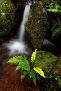
If you have a couple hours on top of Grays I'd rather spend it exploring the area known as Vultures Retreat which has a waterfall, excellent views over the cliff edges and plenty vultures. This area is to the right as you top out, just do a big circular route around that area
Enjoy!
Please Log in or Create an account to join the conversation.
- Smurfatefrog
-

- Offline
- Moderator
-

- Posts: 1134
- Thank you received: 1551
so can anyone recommend any good camping spots up there? Thank you!
Best,
Mike.
Please Log in or Create an account to join the conversation.
- mike_cromberge
-

- Offline
- Junior Member
-

- Posts: 28
- Thank you received: 10
