
Great Himalaya Trail (GHT) - live tracking
AndrewP wrote: So, the messing about is over. Tomorrow I switch on the tracker and start the 3 day hike to Hilsa on the border to Tibet.
It took 8 months of planning to get here and now that it is finally happening, the psyche is high.
Some photos of the trip so far:
Please login or register to view the images attached to this post.
Please Log in or Create an account to join the conversation.

Please Log in or Create an account to join the conversation.

AndrewP wrote: The trail is mostly easy to follow, as long as you take the correct split
Some serious engineering and one of many waterfalls
Goods get carried by yak, horse, donkey and humans
My lodgings in Tumkot. No tea houses around so just a random stranger's house
The Tibetan side of the pass is dry and dusty
The bridge leading to the foreign land and thus my starting point:
Very few wrong splits so far. The GPS is holding up well. I was at 4500m at 6AM this morning. It will be another week before I hit 5000m
Pack until now was about 4kg. 1kg for camera, 500ml water, rest for warm clothes and electronics like headlamp, GPS, phone and spare batteries. No food at all, nor sleeping kit. Tomorrow it will be 14kg. That includes crampons, ice axe, sleeping bag, tent, etc.
Please login or register to view the images attached to this post.
Please Log in or Create an account to join the conversation.
Please Log in or Create an account to join the conversation.
AndrewP wrote: Slow going to Jupal mainly because the pack is way too heavy. Anyway,
I decided to enjoy it as much as possible and camped out for 2 nights,
the second night at a lovely spot.
Got into Jupal early enough to sort out all sorts of admin: permits
for next stage, confirm the route I am doing within that permit (If I
stray north, I get knocked 500 USD), buy some food and dry out gear
that got wet in rain this morning. Most importantly, the excess gear
gets dropped here and collected afterwards so I can enjoy the next
stage.
The 200+ km from here to Kagbeni are the highest ground I will cover
and is the reason for coming here! So, I will go slow enough to enjoy
but light enough to go fast if that makes sense. Now is a good time to
switch the tracker to satellite mode to see the snowy passes. I cross
5 passes of over 5000m in the next few days and spend most of that
time above 4000m. whoop, whoop, whoop
Please Log in or Create an account to join the conversation.
If anyone is curious, current progress:
And intended route as per the attached above. The yellow line a rough indication of scale:
GOOD LUCK! Can't wait to see photos.
Please login or register to view the images attached to this post.
Please Log in or Create an account to join the conversation.
7 October:
AndrewP wrote: The day into Chharka Bhot was interesting. First time on the whole trip that I have lost the path because it was too faint. Had a long stretch of Yak trails. Was remote enough that I saw a herd of about 50 wild buck.
Coming into Chharka Bhot. I actually thought I had overshot so very glad to see this village.
Lovely vegetation to break the desolation high up
The shrik 4 niks staircase. It's either that or river swim.
Typical meal at a restuarant. For a tea house, drop the spinach, veggies and meat. Never a shortage of rice.
I have carried this tent over 200km so may as well use it.
If you decide to leave the tent and sleeping bag behind, your options at 4000m are limited. My night in Doh Tarap.
The first of the 5000m passes. Bagala La.
Approaching Doh Tarap Shrines all over the place
Please login or register to view the images attached to this post.
Please Log in or Create an account to join the conversation.
AndrewP wrote: Accommodation, food and hot shower sorted out. Threw in a beer as well.
The last few days have been the crux of the trip. High altitude and remote. So, I took it slow to start with and sped up once I had sorted out that accommodation issue.
It turned out to be exactly what I wanted. Remote, lovely views, a good challenge and some more time in various tea houses experiencing local culture.
Being me, I did it balls to the wall style with over 100 km at 4000m plus with no tent, sleeping bag or stove. The final 68km day into Kagbeni was out of necessity as much as I just wanted a big day out.
The village of Sante. An oasis of green in the middle of nowhere.
Just another landslide to cross
Finally some clear weather when the high peaks are in sight. The Annapurna massif.
My most interesting bed so far
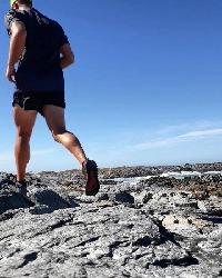
You can actually run at 5000m
Tanya wrote: I think you should change the statement to "I can actually run at 5000m".
Goods train. This is after all an established trading route.
The spot tracker does not show the 25km detour this morning to visit Jomsom to visit an ATM. Which explains the apparent late start. Anyway, going for Thorung La today. Bit cheeky. I feel like those tourists you see on Table Mountain - every one I have passed, who is coming down the pass thinks I am crazy. They are wrong, I know for sure I am
")
9 October
;AndrewP wrote: Miscellaneous stat. For the first 13 days, my average distance is 41.15 km with about 2300m ascent and descent each day. Got to go further tomorrow to get that above a marathon a day!
I took just under 5h30 to do the 21km, 2700m ascent from Kagbeni to the top of Thorung La. That is very fast, hence the huge smile.
Btw - any messages you guys post for Andrew will be passed on to him, so please reply with messages for him

Please login or register to view the images attached to this post.
Please Log in or Create an account to join the conversation.
Please Log in or Create an account to join the conversation.
Any foot triage required thus far in any way?
Then, almost goes without saying, but needs to be said.
He is the most insane over the top athlete compared to what is deemed as average high risk behaviour as it stands for "normal" people.
I do understand his level of fitness moves that high risk boundary out somewhat, but GawdDamn - just short of a Marathon a day over double digit multiple days back-to-back in that terrain is gobsmackingly friken insane... with an almost self-reliant support structure.
I question how many people truly realise what an achievement that is...
Please Log in or Create an account to join the conversation.
