
Snow Watch 2022
19 Apr 2022 14:35 #77593
by JonWells
Replied by JonWells on topic Snow Watch 2022
This past weekend saw some further snowfalls along some of the higher peaks across the escarpment. Here is today's Terra Modis satellite image showing the remaining snow in light blue:
Please login or register to view the image attached to this post.
Please Log in or Create an account to join the conversation.

17 May 2022 22:31 #77692
by TheRealDave
Replied by TheRealDave on topic Snow Watch 2022
It looks like it might snow in the Berg this weekend. @JonWells, any expert forecasts?
Please Log in or Create an account to join the conversation.
- TheRealDave
-
- Offline
- Elite Member
-

Less
More
- Posts: 195
- Thank you received: 256
18 May 2022 07:25 #77693
by JonWells
Replied by JonWells on topic Snow Watch 2022
Indeed Dave
. The models have been indicating a possible significant snow event for a few days now, but I generally wait until 3 days before to post here, due to how wildly unreliable the longer range forecasts can be. But I can say, that as of today, the system is still looking on track to deliver some widespread snow across the Drakensberg, and even to some other parts of the country. At this stage, snow is expected to begin on Friday night, and continue through to late Saturday night. Falls exceeding 20-30cm are possible across much of the escarpment, with some suggestions of even 50cm+ for some of the highest peaks. These numbers may reduce closer to the time, but for now this is what the models are indicating.
This image is hidden for guests.
Please login or register to view the image attached to this post.
The following user(s) said Thank You: DeonS, firephish, hikingle, MarkT, Captain, supertramp, Papa Dragon, ivan, TheRealDave, riaan300, Carl Gebhard
Please Log in or Create an account to join the conversation.
19 May 2022 08:05 #77705
by JonWells
Replied by JonWells on topic Snow Watch 2022
Quick update here. Recent model runs are indicating slightly higher temperatures than previous runs, meaning that lower altitude snow is now a lot less likely.
Heavy snow is still possible for the escarpment, especially the higher regions of the Central and Northern Berg:
Heavy snow is still possible for the escarpment, especially the higher regions of the Central and Northern Berg:
Please login or register to view the image attached to this post.
Please Log in or Create an account to join the conversation.
20 May 2022 14:41 - 20 May 2022 14:59 #77710
by tiska
The Icon model is holding on to some snow this weekend.
it’s unusually far north - normally the snow hits the southern Berg more.
i think this is because the mechanism that is making the snow is a cut off low produced by a breaking Rossby wave in the upper atmosphere which leaves behind a blob of very cold Southern Ocean air. That blob is thrown quite far north by the breaking wave. In the case of a breaking wave, the cold air becomes semi-stationary over southern Africa for a few days. If the wave does not break (i.e. no cut off low) then the wave moves off to the east in a day and the mechanism making the snow doesn't get the chance to dump on the high ground of Lesotho - it will melt in the atmosphere before it hits the ground somewhere to the east of Lesotho and fall as drizzle.
Replied by tiska on topic Snow Watch 2022
The Icon model is holding on to some snow this weekend.
it’s unusually far north - normally the snow hits the southern Berg more.
i think this is because the mechanism that is making the snow is a cut off low produced by a breaking Rossby wave in the upper atmosphere which leaves behind a blob of very cold Southern Ocean air. That blob is thrown quite far north by the breaking wave. In the case of a breaking wave, the cold air becomes semi-stationary over southern Africa for a few days. If the wave does not break (i.e. no cut off low) then the wave moves off to the east in a day and the mechanism making the snow doesn't get the chance to dump on the high ground of Lesotho - it will melt in the atmosphere before it hits the ground somewhere to the east of Lesotho and fall as drizzle.
Please login or register to view the images attached to this post.
Last edit: 20 May 2022 14:59 by tiska.
Please Log in or Create an account to join the conversation.

20 May 2022 14:46 - 20 May 2022 14:48 #77711
by tiska
Winds in upper air-
The blue colour over the SA/Botswana border is the middle of the cold blob of air that has broken away from the Southern Ocean air.
Replied by tiska on topic Snow Watch 2022
Winds in upper air-
The blue colour over the SA/Botswana border is the middle of the cold blob of air that has broken away from the Southern Ocean air.
Please login or register to view the images attached to this post.
Last edit: 20 May 2022 14:48 by tiska.
Please Log in or Create an account to join the conversation.
22 May 2022 10:16 - 22 May 2022 11:40 #77715
by tiska
The Icon forecast model held on to the localised blob of snow in the far northern Berg right up to real time (see below)
This seems to be because that is where the model was coldest (see forecast model temperature map above).
The ECMWF model simulated much more widespread snow across the Berg instead (see below).
Snow has been reported at Sani with a dusting evident on the Cathedral Peak range.
JonWells commented on the large spread in the forecast models at the start of the medium range forecasts. That large spread was retained up to real time. Forecast models are initialised by real measurements of the atmosphere. What the models forecast into the future depends more and more on the forecast model the further ahead in time the model runs and the further away they are in time from the real starting conditions. But as the event of interest comes closer in time, the models should converge to a similar forecast. If this doesn’t happen - as was the case here - then it is because the observations of the real atmosphere are too sparse i.e. too far apart from one another or else non-existent. In the case of southern Africa, observations are critically sparse so the models are not brought precisely to heel as the event of interest approaches. And the view the models have of the world is their own view, not that of the real world. All models predicted the severe event this weekend but differed in detail. Where that detail depends on the models getting a key threshold like the altitude of freezing point just right - as is needed for snow forecasts - the differences between the models are much easier see.
The question for those in the mountains is whether one model is actually more reliable than another. The modelling centres that build the models will evaluate the models for a wide range of metrics, usually those of most interest to the country where the modelling centre is located. For something like snow in the Berg, with only a handful of us interested, that evaluation won’t happen. And since model improvement requires those metrics as a starter, we’re not likely to see deliberate improvements. Neither will we see a return to less sparse conventional observations over southern Africa such as weather balloons. That network over southern Africa was at least 10 times better in the 1970s than it is now. The network is in terminal decline. A bit like Eskom.
Replied by tiska on topic Snow Watch 2022
The Icon forecast model held on to the localised blob of snow in the far northern Berg right up to real time (see below)
This seems to be because that is where the model was coldest (see forecast model temperature map above).
The ECMWF model simulated much more widespread snow across the Berg instead (see below).
Snow has been reported at Sani with a dusting evident on the Cathedral Peak range.
JonWells commented on the large spread in the forecast models at the start of the medium range forecasts. That large spread was retained up to real time. Forecast models are initialised by real measurements of the atmosphere. What the models forecast into the future depends more and more on the forecast model the further ahead in time the model runs and the further away they are in time from the real starting conditions. But as the event of interest comes closer in time, the models should converge to a similar forecast. If this doesn’t happen - as was the case here - then it is because the observations of the real atmosphere are too sparse i.e. too far apart from one another or else non-existent. In the case of southern Africa, observations are critically sparse so the models are not brought precisely to heel as the event of interest approaches. And the view the models have of the world is their own view, not that of the real world. All models predicted the severe event this weekend but differed in detail. Where that detail depends on the models getting a key threshold like the altitude of freezing point just right - as is needed for snow forecasts - the differences between the models are much easier see.
The question for those in the mountains is whether one model is actually more reliable than another. The modelling centres that build the models will evaluate the models for a wide range of metrics, usually those of most interest to the country where the modelling centre is located. For something like snow in the Berg, with only a handful of us interested, that evaluation won’t happen. And since model improvement requires those metrics as a starter, we’re not likely to see deliberate improvements. Neither will we see a return to less sparse conventional observations over southern Africa such as weather balloons. That network over southern Africa was at least 10 times better in the 1970s than it is now. The network is in terminal decline. A bit like Eskom.
Please login or register to view the images attached to this post.
Last edit: 22 May 2022 11:40 by tiska.
Please Log in or Create an account to join the conversation.
23 May 2022 13:25 - 23 May 2022 13:26 #77717
by JonWells
Replied by JonWells on topic Snow Watch 2022
Here is today's satellite image showing the extent of the remaining snow in blue (white is cloud). Good snow right across the escarpment from the Chain ladders to past Bushman's Nek.
Snowline is currently at 3000m in the North, and about 2500m in the South.
There have been reports that the snow above Sani Pass being around 20-30cm deep, but as deep as 70cm in some of the snowdrifts. Both Shaleburn (Underberg) and Giant's Castle Camp weather stations received around 50mm of rain, so it is likely that the high ground in these regions would have had up to 50cm of snow. Given the time of year, this snow should be around for quite some time, especially on the South facing slopes and shaded gulleys:
Please login or register to view the image attached to this post.
Last edit: 23 May 2022 13:26 by JonWells.
Please Log in or Create an account to join the conversation.
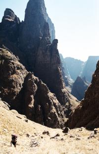
27 May 2022 20:24 - 27 May 2022 20:26 #77725
by tonymarshall
Replied by tonymarshall on topic Snow Watch 2022
During this past week I did a three day hike at Giant’s Castle of the Contour Path from Langalibalele Ridge to Taylor’s Pass, entering via Langalibalele Ridge and exiting via Oribi Ridge Route, and although I wasn’t in the snow I got a good view of the snow on the summit during my hike lower down.
The snow on Giant’s Castle, Giant’s Castle Pass and Long Wall from Langalibalele Ridge on Tuesday.
The Carbineers peaks and top of Langalibalele Pass from the contour path.
I had decided to include the smuggler’s shortcut over the ridge into Elandshoek Pass approach into my hike, and to climb to the summit of The Sisters (north) peak while I was on the top of the ridge.
The snow on Elandshoek Pass (the gully to the left of the photo) and South Ridge from the summit of the north Sister on Wednesday.
From the normal approach to Elandshoek Pass, the snow on the escarpment around Redi, The Hawk and The Tent, with snow visible on the southern berg at the left in the background.
On my walk out on Thursday, snow on the escarpment from Langalibalele Pass to Cathkin Peak, the photo taken from Oribi Ridge Route.
It was apparent that this was quite a significant and widespread snowfall, and more than expected, although the snow was confined to the upper levels of the escarpment and Lesotho, and that the snow on the summit was quite deep.
Please login or register to view the images attached to this post.
Last edit: 27 May 2022 20:26 by tonymarshall. Reason: Correct formatting
The following user(s) said Thank You: elinda, JonWells, DeonS, firephish, ghaznavid, hikingle, Smurfatefrog, Captain, Richard Hunt, Riaang, Papa Dragon, TheRealDave, Christinejvr, riaan300, wildingo, andrehayward, Rossp
Please Log in or Create an account to join the conversation.
- tonymarshall
-

- Offline
- VE Advisory
-

Less
More
- Posts: 770
- Thank you received: 2244
14 Jun 2022 08:10 #77777
by BergAttie
Replied by BergAttie on topic Snow Watch 2022
Can anyone that has been in the high berg between Ndumeni and Champagne Castle within the last couple of days to a week enlighten me on the snow cover on top? Need to pick shoes and I am not too keen on my trail running shoes in snow deeper than 3-4cm in them. This could of course change with new snowfall before Friday but at the moment that looks unlikely.
Please Log in or Create an account to join the conversation.
