Cockade Pass
28 Mar 2015 20:48 #63232
by Kevinva
Replied by Kevinva on topic Cockade Pass
Do you perhaps still have your gpx track data?
Please Log in or Create an account to join the conversation.

30 Mar 2015 10:54 #63237
by karlito
Replied by karlito on topic Cockade Pass
Please Log in or Create an account to join the conversation.

30 Mar 2015 20:06 #63248
by supertramp
Replied by supertramp on topic Cockade Pass
Hi Kevin
Yes, I do have the GPX file from my GPS (it may come in useful with the downloadable one on VE). Pop me a PM and I'll email it you.
Regards,
Yes, I do have the GPX file from my GPS (it may come in useful with the downloadable one on VE). Pop me a PM and I'll email it you.
Regards,
Please Log in or Create an account to join the conversation.
- supertramp
-
- Offline
- Elite Member
-

Less
More
- Posts: 225
- Thank you received: 455
31 Mar 2015 08:12 #63255
by Riaang
Replied by Riaang on topic Cockade Pass
Hi supertramp,
Can you please mail it to me too, I'll pm you in a sec. Looking at the track on VE the pass has an interesting graph, with a couple of steep "steps" followed by flatter sections. Does your track follow the same trend? I'd be interested to see if your followed a different line up the pass.
Can you please mail it to me too, I'll pm you in a sec. Looking at the track on VE the pass has an interesting graph, with a couple of steep "steps" followed by flatter sections. Does your track follow the same trend? I'd be interested to see if your followed a different line up the pass.
Please Log in or Create an account to join the conversation.

31 Mar 2015 08:46 #63256
by karlito
Replied by karlito on topic Cockade Pass
If you download the Xeni Pass track here on VE you will see it also has some slight variations on the part where they overlap.
Please Log in or Create an account to join the conversation.
17 Apr 2015 06:58 - 17 Apr 2015 07:11 #63405
by tonymarshall
Replied by tonymarshall on topic Cockade Pass
In mid March intrepid, ClimbyKel, Harry and tonymarshall did a 3 day weekend trip at Didima, ascending Cockade Pass and descending Mlambonja Pass.
The first afternoon was spent hiking up to the Cockade Campsite via the Neptune Pools path from Cathedral Peak Hotel, up the ridge between the Xeni and Mlambonja Rivers, a short way along the Contour Path to the Xeni River Crossing, and upstream to the Cockade Campsite. We had a few drops of rain along the Contour Path, but it stopped by the time we were ready to set up camp. The photo below shows the overgrown section of Contour Path in the Xeni valley on the left.
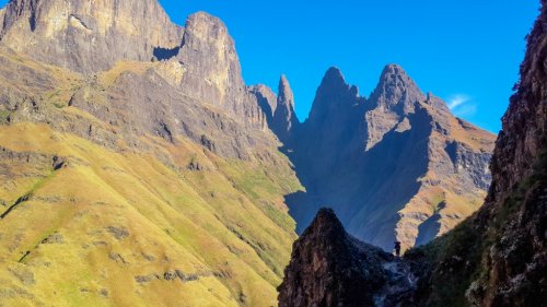
The next morning was clear, and we experienced the legendary sunrise on the escarpment from Cockade Campsite, which the photo below doesn’t adequately capture. The peak at the left of the photo with the pinnacle in front is Cockade, named after a decoration (feather) on a hat, which can be related to the pinnacle and the peak. The Plume is to the right of Cockade, Elephant is the peak at the centre of the photo, and Xeni Peak is the centre peak of the three at the right. The route of the pass goes up the valley, and to the left behind the foreground ridge and the Plume, topping out between Cockade and Elephant.
Soon after departing upstream, we encountered the dreaded Xeni Valley bush, and fought our way through this for several hundred metres.
The valley sides are quite steep, as can be seen in this view downstream, so you are forced to stay in the bottom near the river, alternating between boulder hopping in the river and forcing your way through the bush.
Here and there we found bits of trail, but generally just tried to follow the area of thinnest bush.
After a while we could get out on the right (true left) side of the stream, onto a terrace with low vegetation that was quite easy to walk through. This terrace can be seen in the photo below, looking back downstream.
Later we crossed to the left (true right) side of the Xeni stream, and stopped for a break at the Cockade – Xeni junction, where intrepid and I tried to dry our sweat soaked shirts a bit. Here we turned left to go up Cockade Pass, the gully to the left behind Harry, and the Xeni Pass route goes straight up the river on the right and to the right of Xeni Peak in the background of the photo below.
Soon after departing from the junction, the mist and rain clouds moved in. The pass itself starts at the junction, and the first section is in similar vegetation to the terrace we were on earlier, but because of the steeper slope is a lot harder going as shown in this photo looking downstream.
The first afternoon was spent hiking up to the Cockade Campsite via the Neptune Pools path from Cathedral Peak Hotel, up the ridge between the Xeni and Mlambonja Rivers, a short way along the Contour Path to the Xeni River Crossing, and upstream to the Cockade Campsite. We had a few drops of rain along the Contour Path, but it stopped by the time we were ready to set up camp. The photo below shows the overgrown section of Contour Path in the Xeni valley on the left.
The next morning was clear, and we experienced the legendary sunrise on the escarpment from Cockade Campsite, which the photo below doesn’t adequately capture. The peak at the left of the photo with the pinnacle in front is Cockade, named after a decoration (feather) on a hat, which can be related to the pinnacle and the peak. The Plume is to the right of Cockade, Elephant is the peak at the centre of the photo, and Xeni Peak is the centre peak of the three at the right. The route of the pass goes up the valley, and to the left behind the foreground ridge and the Plume, topping out between Cockade and Elephant.
Soon after departing upstream, we encountered the dreaded Xeni Valley bush, and fought our way through this for several hundred metres.
The valley sides are quite steep, as can be seen in this view downstream, so you are forced to stay in the bottom near the river, alternating between boulder hopping in the river and forcing your way through the bush.
Here and there we found bits of trail, but generally just tried to follow the area of thinnest bush.
After a while we could get out on the right (true left) side of the stream, onto a terrace with low vegetation that was quite easy to walk through. This terrace can be seen in the photo below, looking back downstream.
Later we crossed to the left (true right) side of the Xeni stream, and stopped for a break at the Cockade – Xeni junction, where intrepid and I tried to dry our sweat soaked shirts a bit. Here we turned left to go up Cockade Pass, the gully to the left behind Harry, and the Xeni Pass route goes straight up the river on the right and to the right of Xeni Peak in the background of the photo below.
Soon after departing from the junction, the mist and rain clouds moved in. The pass itself starts at the junction, and the first section is in similar vegetation to the terrace we were on earlier, but because of the steeper slope is a lot harder going as shown in this photo looking downstream.
Please login or register to view the images attached to this post.
Last edit: 17 Apr 2015 07:11 by tonymarshall.
Please Log in or Create an account to join the conversation.
- tonymarshall
-

- Offline
- VE Advisory
-

Less
More
- Posts: 768
- Thank you received: 2233
17 Apr 2015 07:02 #63406
by tonymarshall
Replied by tonymarshall on topic Cockade Pass
Again we seemed to be keeping to the right (true left) of the valley.
In places there is a trail, but it was quite difficult to follow and we kept losing it quite easily. It’s probably just as easy to head up through the vegetation anywhere than concentrate on following the trail.
Higher up the valley narrows and you are forced into the boulder bed, a view looking down the narrow gulley.
A view up the boulder bed section, just before the valley widened again and the upper grass slope section started.
It started raining when we reached the grass slope, and we took a rest stop to put on rain gear, before tackling the final section of the pass.
Visibility was quite poor in the rain and mist, and somewhere on the grass slope there is a split in the route, the usual route goes to the right, and a variation to the left. The two routes top out about 100 m apart on the summit, with the left variation about 20 m higher. We found ourselves on the left variation, without really having seen the split in the poor visibility, but knew it would take us to the summit.
Again the route narrowed, and it was quite eerie ascending the narrow grass slope between rock walls in the mist and rain.
Kelly had gone ahead, and standing with her pack off at the top of the pass, we were met with the welcome news that we were at the top of the pass as we emerged from the narrow rock passage, just as the weather cleared a bit too.
We had lunch at the top of the pass, after intrepid and I had summited Cockade, and a sudden deluge of rain and hail, and then headed off via the Elephant Cutback to Twins, where we would overnight at Twins Annex Cave.
Please login or register to view the images attached to this post.
The following user(s) said Thank You: Serious tribe, DeonS, kliktrak, ghaznavid, Smurfatefrog, Drakensbergie, Riaang, Christinejvr
Please Log in or Create an account to join the conversation.
- tonymarshall
-
- Offline
- VE Advisory
-
Less
More
- Posts: 768
- Thank you received: 2233
17 Apr 2015 08:02 #63407
by intrepid
Take nothing but litter, leave nothing but a cleaner Drakensberg.
Replied by intrepid on topic Cockade Pass
What was surprising to me was how easily we got onto the southern variation even though we didn't intend to, in spite of having done Cockade Pass before. Shows how misty conditions and several years of graying memory can mess you around.
Take nothing but litter, leave nothing but a cleaner Drakensberg.
Please Log in or Create an account to join the conversation.

17 Apr 2015 09:39 #63410
by Riaang
Replied by Riaang on topic Cockade Pass
I also found that, when very tired, (for me) it is easy to loose concentration and take the wrong turnoff or miss the intended one. GPS's were invented for people like me 
Please Log in or Create an account to join the conversation.
04 Apr 2016 20:58 #67633
by Mattyk
Replied by Mattyk on topic Cockade Pass
We did this pass about two weeks ago (march 2016), and the pass itself was quite beautiful at the top section where there is a lot of bouldering. We came down the pass as our exit after a long day of going up past cathedral peak, doing the bell traverse and up Mlambonja pass. All was good until we started to hit the thick bush at the bottom of the pass. I would recommend steering clear of this pass just for the sole reason of how frustratingly thick that bush is (3kms took over 2 hrs).
Please Log in or Create an account to join the conversation.