
Cockade Pass
I did this route the other way round last year (day hike up Cockade down Bell Traverse) - the trick with the lower section is to ignore the cairns. If the river is low, simply follow the water course.Mattyk wrote: I would recommend steering clear of this pass just for the sole reason of how frustratingly thick that bush is (3kms took over 2 hrs).
I have done Cockade Pass 3 times, the first time we also struggled with the overgrowth - but the second and third time, we knew better and stayed in the river. I rate it as comfortably the most scenic pass in the Berg (well, out of the 59 I have done anyway) - definitely not a pass to miss out on.
Please Log in or Create an account to join the conversation.

For all the frustration that’s been expressed about the bushy approach to Cockade, I have to say that we experienced little difficulty with this section - and my sister is not a fit hiker. We took Ghaznavid’s tip and started off by keeping to the watercourse, but we soon found a well-marked path heading up the riverbed on the right, which was easy to follow and required almost no bush-whacking at all. The vegetation is naturally thinner in winter, but this section didn't seem as hard as it's been made out to be.
We followed this path up to the terrace section, which turned out to be harder going than the riverbed because of all the weedy shrubs; so it's probably easier (at least in winter) to simply stay in the riverbed and follow the path. One could stay on the terrace all the way up to the woody gully just before the waterfalls, but the lack of a path slows you down.
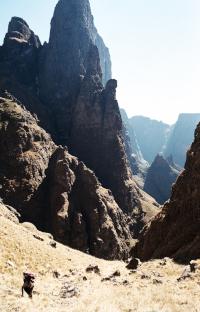
One has to second Ghaz’s rating of Cockade: the views are majestic:
There is a continuous path all the way up the right side (true left) of Cockade Pass until one moves into the bouldery gully:
Thereafter one comes to a rocky bowl, and it is not obvious to the first-timer that the pass continues up to the left. In fact, there is a narrow gully heading out of this bowl to the right, which looked like it might allow for a shortcut to the Elephant traverse. We stuck to the known route.
It's a stunning pass with amazing vistas. The only real difficulty was the steepness near the top.
On the way to Mlambonja Pass we came across a pile of large white sacks lying by the Kwakwatsi - apparently unattended. But as we rounded a slope, we startled two smugglers enjoying the last rays of afternoon sun, and, after exchanging friendly waves, continued on our way. They promptly jumped up, loaded their donkeys, and started following us, which was a little disconcerting. So we picked up the pace, and from the top of Mlambonja watched them cross the river and carry on along the contour path, probably towards Ntonjelana Pass or Easter Cave. I really feel for these guys: life up there must be hard enough as it is, and this is a hard way to make a living.
Sunrise from Twins Cave:
And a look back at the beautiful Mlambonja Valley:
It's a very beautiful route, certainly the most beautiful route I've done in the Berg so far.
But would someone please explain to me where on earth Twins Annex is? I walked all the way round Twins Peak until I came to a large cairn, after which the path seemed to descend a small buttress and then perhaps shortcut into Mlambonja. But I simply could not find the cave.
Please login or register to view the images attached to this post.
Please Log in or Create an account to join the conversation.
- TheRealDave
-
- Offline
- Elite Member
-

- Posts: 195
- Thank you received: 256
"But would someone please explain to me where on earth Twins Annex is? I walked all the way round Twins Peak until I came to a large cairn, after which the path seemed to descend a small buttress and then perhaps shortcut into Mlambonja. But I simply could not find the cave."
It's the other way Dave.
As you come over the col between Twins and the escarpment, where the path to Twins cave veers off to thright, there is a path to the left as well.
The Annexe is a couple of hundred metres along this path...
Please Log in or Create an account to join the conversation.
- Papa Dragon
-

- Offline
- Platinum Member
-

- Posts: 763
- Thank you received: 647
Please login or register to view the image attached to this post.
Please Log in or Create an account to join the conversation.
- Smurfatefrog
-

- Offline
- Moderator
-

- Posts: 1132
- Thank you received: 1550
Please Log in or Create an account to join the conversation.
- TheRealDave
-
- Offline
- Elite Member
-
- Posts: 195
- Thank you received: 256
Please Log in or Create an account to join the conversation.
- tonymarshall
-

- Offline
- VE Advisory
-
- Posts: 768
- Thank you received: 2233
The pass itself is properly steep, but the views make up for the toughness. I can see how in wet weather or mist it can cause suffering. I also think descending the pass will be tougher on the legs, and the path could be lost more easily. Minimal bush whacking when following the path on the right upward, and long pants help with the short shrubs on the terraces.
Ultimately when looping Cockade with Mlambonja, you really get great views of the Cathedral range and the Xeni cutback. The most scenic loop I have done.
A few photos:
Early start near the Cockade campsite
One of the terrases on the true left of the Xeni river
Final section leading up to the Cockade/Xeni split. You cross the river from right to left, roughly in the middle of the photo where the waterfall is visible.
After about 100m turn left into Cockade pass proper
The steepness of Cockade is not to be underestimated.
Final (left) gully, with light from the escarpment shining through
A magnificent view from the top
Please login or register to view the images attached to this post.
Please Log in or Create an account to join the conversation.

Please Log in or Create an account to join the conversation.
- TheRealDave
-
- Offline
- Elite Member
-
- Posts: 195
- Thank you received: 256
That whole area around Cockade is really super spectacular. Next time, try one of the Xeni legs or Mlambonja Buttress south pass. I'm sure you won't be disappointed with these options.
I've done Cockade down both in good weather and rainy weather, and in the rain it was very dodgy. Lots of loose rocks on this pass in general, but the wet made them very slippery. According to my wife, to date, one of her toughest down passes (in the wet).
Please Log in or Create an account to join the conversation.

Please Log in or Create an account to join the conversation.

