
Injisuthi Pass
In June 2016 I did a thorough examination of the escarpment between the two Injisuthi Buttresses, with the express purpose of seeing if there was a route up through the rock bands. From my observations, and in my opinion, there is no way the mythical Hilton Pass can top out between the Buttresses. It may be possible to climb this, but it will be serious rock climbing, much more difficult than the marked pass. I wonder if Barnes and co didn't perhaps use the valley between the Buttresses as an approach, traverse south, and then summit via the marked pass.
Please Log in or Create an account to join the conversation.
- tonymarshall
-

- Offline
- VE Advisory
-

- Posts: 768
- Thank you received: 2233
Regarding Injisuthi Pass - the climbing section is no joke. I chatted to Clem about this pass yesterday, he did it ages ago and rates the "step across" as the hardest part (when the cliff is almost vertical, you have to leave the chimney to access a grass ledge - scary is an understatement). The pass lacks sufficient drainage basin to be easily washed out (similar to Mbundini Pass, it tops out on top of a ridge), but the erosion on the cliff has really rendered very dangerous.
My thoughts on it:
1) Rating 8/10** RT (X)
Explanation of the rating for those unfamiliar with it - 8/10 is exertion difficulty, on a scale of Chain Ladders to the hardest Berg monsters. ** is quality - I only give it 2 because of the view. RT is a differentiation between regular, rock (r), Rock (R) and ROCK (RT) - being scrambly but easy, vs having to pass/haul packs vs requiring technical rock climbing. I have X-rated the pass due to the danger the pass includes.
2) The approach - the lower section is very scrambly, but any experienced hiker should be able to find a way up in good weather. It is one of those approaches that requires care, but is not bad if you look out properly - very similar to Mponjwane Pass in this regard.
3) The middle - our line worked fine. We could have continued higher before traversing in, or taken Intrepid's line and traversed in lower - doesn't really matter. The middle of the pass is fine, nothing wrong with it.
4) The top = death trap
5) I asked a few years back if this can actually be classified as a pass - and my answer now is: no, this is a rock climbing route, not a pass.
Would I recommend it to others? No.
Please Log in or Create an account to join the conversation.

Please login or register to view the images attached to this post.
Please Log in or Create an account to join the conversation.
The climbing RD for the Greater Injasuthi Buttress mentions the following about the descent: "Careful scrambling down the gully between the Greater and Lesser Injasuthi Buttresses and an abseil leads to easy grass slopes which are followed down and around to the left (facing downward) to the long grass slope leading down into the valley."
“Today is your day! Your mountain is waiting, So… get on your way!”
Please Log in or Create an account to join the conversation.

Maybe my post above wasn't that well worded when I wrote "there is no way the mythical Hilton Pass can top out between the Buttresses". It should have been qualified with something extra to the effect of; without technical climbing, as or more difficult as the marked pass. I was trying to say there is no easy way up between the Buttresses, and ending up inadvertently implying that there is no way up at all.
Just for interest sake, what does the climbing RD for the Greater Injasuthi Buttress mention about the ascent?
Please Log in or Create an account to join the conversation.
- tonymarshall
-
- Offline
- VE Advisory
-
- Posts: 768
- Thank you received: 2233
tonymarshall wrote: Thanks Viking,
Maybe my post above wasn't that well worded when I wrote "there is no way the mythical Hilton Pass can top out between the Buttresses". It should have been qualified with something extra to the effect of; without technical climbing, as or more difficult as the marked pass. I was trying to say there is no easy way up between the Buttresses, and ending up inadvertently implying that there is no way up at all.
Just for interest sake, what does the climbing RD for the Greater Injasuthi Buttress mention about the ascent?
Oh no Tony, I was just adding some info to the topic, it wasn't a rebuttal of any sorts. To my mind that info adds to the current suggestion that it's difficult to impossible without climbing etc..
As for the Greater Buttress route - it's up the North East Arete and goes at G2/21 with a total of 6 pitches. 15/17/21/21/13/15. The approach is from the Injasuthi valley then up and into the col between the Buttress and Scaly Peak.
“Today is your day! Your mountain is waiting, So… get on your way!”
Please Log in or Create an account to join the conversation.

Please Log in or Create an account to join the conversation.
ghaznavid wrote: …..
4) The top = death trap
5) I asked a few years back if this can actually be classified as a pass - and my answer now is: no, this is a rock climbing route, not a pass.
Would I recommend it to others? No.
intrepid wrote:
It's a beaut of a gully, very sustained and just below the top it has a technical chimney, perhaps just under 10m in length and possibly around a grade 12. We had climbing equipment with, 2 of us soloed it and set up a belay for the rest.
intrepid wrote:
......Injasuthi Pass can be done without ropes. I did do the short crux section without ropes and with a pack on, but must add that I did slip and fell half a meter or so before I caught myself. If I had fallen further I probably would have broken an ankle or a leg. I did set up a belay for 2 of our members at the time, who definitely wanted it. Many technical passes can be called technical simply because they do require some moves on rock - but this doesn't necessarily make it hard overall…..
It’s very interesting to read the different experiences and perspectives people have had in the mountains!
Personally, I think the impression our group had of the pass was more similar to Intrepid’s group, rather than Ghaz and Biomech’s. I think we made it from below the crux to the top of the pass in about an hour or so.
On a side note, did you guys take a VERY scenic route from Hilton Pass to the top of Leslies that resulted in 7 or 8km??

 That section is surely 4 - 4.5km max.
 Please Log in or Create an account to join the conversation.
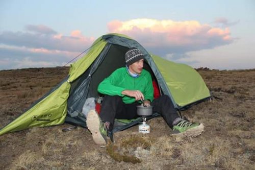
Our group of seven – Neil Margetts, Elinda, Thora, Lorinda, Stephan, Christine and tonymarshall - left Injisuthi camp at midday on Friday, and tented at Leslies campsite.
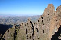
Saturday morning was clear, although mist was forecast and we were not too optimistic of having clear weather. We could see our destination for the day, our goal was to get up Injisuthi Pass, and tent on the summit or use Hilton Cave. In the photo below, taken at our campsite at the base of Leslies Pass, the ridge to Leslies Pass is at the right, and we would descend the grass slope behind me to go up the valley behind the ridge running across the centre of the photo, to the pass at the middle of the skyline. Photo courtesy of Elinda.
We left just after 6h30, heading into the valley, and there was already mist coming and going around the escarpment. The first part up the valley was straightforward, taking the path of least resistance between either the river bed or grass bank. A bit further on the valley sides became steep and we were forced into the riverbed. The photos below give an idea of the boulder hopping and the steepness of the valley.
We reached a waterfall and had to deviate around on the bank to the left, where Neil placed a rope for the group to pull on to get up. In the photo below Christine ascends out of the river bed using the rope.
Neil was just about to put the rope away, and I had gone ahead and saw that we needed to cross a deep sidestream gully with a wet slab, so we put the rope there again to help everyone get down and back into the main stream, where we had a tea break. In the photo below, Stephan (Christine’s husband, not on VE) descends the bottom dry section of the slope while I assist. Photo courtesy of Elinda.
After tea we bypassed the next waterfall on a slope to the left again.
Please login or register to view the images attached to this post.
Please Log in or Create an account to join the conversation.
- tonymarshall
-
- Offline
- VE Advisory
-
- Posts: 768
- Thank you received: 2233
In the photo below Christine and Stephan ascend around another waterfall where a rope wasn’t necessary.
Two more waterfalls were bypassed without a rope, and the photos below show the general terrain
At the next waterfall bypass Neil placed a rope at the exposed exit from the river and the group went up onto the slope, which had a lot of helichrysum bushes, so although it was difficult getting through the bushes they were great to hold onto on the steep slope (and to tie the rope onto). We bypassed the next three waterfalls by sticking continuously to the sideslope, and were glad to get out of the bushes once above the upper waterfall.
We had lunch in the mist, not really sure where we were, as everyone’s gps had gone wandering, and then headed up a steep bank, where it cleared a bit and we could see we needed to head left of where we were to get back into the main gully. The mist had lifted below, and the photo below shows the boulder hopping section towards the top of the main gully with the view back down the pass.
Please login or register to view the images attached to this post.
Please Log in or Create an account to join the conversation.
- tonymarshall
-
- Offline
- VE Advisory
-
- Posts: 768
- Thank you received: 2233
