
- Forum
- Drakensberg Forum
- Drakensberg Hiking
- AmaNgwane (Mnweni & other areas)
- Mnweni Pass - Rockeries Pass Loop
Mnweni Pass - Rockeries Pass Loop
13 Sep 2023 17:28 #78746
by Sabine
Replied by Sabine on topic Mnweni Pass - Rockeries Pass Loop
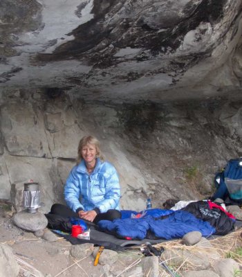
Thank you Wandelaar, that makes a lot of sense. I was up there end of April and the water at point X that I marked was already dodgy but still flowing ever so slightly.
Please Log in or Create an account to join the conversation.
16 Oct 2023 06:55 #78765
by Drakie1
Replied by Drakie1 on topic Mnweni Pass - Rockeries Pass Loop
Does anyone know if Mnweni area had rain the last couple of days? What is the condition of the road to Mnweni and the situation with water higher up from the line between Mnweni pass summit and Rockeries........ towards the plato where the Senqu river originates?
Please Log in or Create an account to join the conversation.

20 May 2024 19:22 #79098
by sander
Replied by sander on topic Mnweni Pass - Rockeries Pass Loop
Hello Everyone,
I'm going on a trip to South Africa next week and I'm really lurking at walking the Mnweni circuit. I'm planning to arrive at the mnweni cultural centre Sunday afternoon, May 26th and start hiking on Monday morning to get hopefully back to the centre on Wednesday afternoon. I'm trying to find as much info as possible reading about this but my biggest hesitation is setting out to do this alone. I know it's strongly advised against. I am an experienced overnight hiker but I have no experience with South Africa, so I am currently weighing my options and see what is the responsible thing to do. I know this is a very long shot but is anyone maybe planning to do the same hike around these days and willing to team up?")
My 3 main concerns are: being mugged, not finding water and injury (although I'm generally a very careful person and never got injured before on hikes)
Can I actually expect any other hikers on the trail around this time of year, given that it's weekdays and not the weekend?
Thanks a lot in advance for all your insights and reactions!
kind regards,
Sander from Belgium
I'm going on a trip to South Africa next week and I'm really lurking at walking the Mnweni circuit. I'm planning to arrive at the mnweni cultural centre Sunday afternoon, May 26th and start hiking on Monday morning to get hopefully back to the centre on Wednesday afternoon. I'm trying to find as much info as possible reading about this but my biggest hesitation is setting out to do this alone. I know it's strongly advised against. I am an experienced overnight hiker but I have no experience with South Africa, so I am currently weighing my options and see what is the responsible thing to do. I know this is a very long shot but is anyone maybe planning to do the same hike around these days and willing to team up?
My 3 main concerns are: being mugged, not finding water and injury (although I'm generally a very careful person and never got injured before on hikes)
Can I actually expect any other hikers on the trail around this time of year, given that it's weekdays and not the weekend?
Thanks a lot in advance for all your insights and reactions!
kind regards,
Sander from Belgium
Please Log in or Create an account to join the conversation.
21 May 2024 11:02 #79100
by Sabine
Replied by Sabine on topic Mnweni Pass - Rockeries Pass Loop
Hi Sander,
If you don't find a group to join, maybe consider getting a guide at the Mnweni Cultural Centre. They are very knowledgable.
If you don't find a group to join, maybe consider getting a guide at the Mnweni Cultural Centre. They are very knowledgable.
Please Log in or Create an account to join the conversation.
22 May 2024 16:18 #79103
by sander
Replied by sander on topic Mnweni Pass - Rockeries Pass Loop
Hi Sabine,
Thanks a lot for your reaction.
I know I'm a bit last minute so I'm not hoping to find a group. After some thought I would find it irresponsible to venture out alone in an area I don't know. I will consider getting a guide, thanks for the suggestion!
Kind regards!
Thanks a lot for your reaction.
I know I'm a bit last minute so I'm not hoping to find a group. After some thought I would find it irresponsible to venture out alone in an area I don't know. I will consider getting a guide, thanks for the suggestion!
Kind regards!
Please Log in or Create an account to join the conversation.
22 Mar 2026 16:50 #80266
by Nadia.Claassen
Replied by Nadia.Claassen on topic Mnweni Pass - Rockeries Pass Loop
Hi all, we are planning a 3.5 day hike, starting at mNweni cultural center, up Rockeries pass, behind the Saddle, and down Ntonjelana Pass. We want day 4 to be a short day. Please recommend where to sleep each day and if possible, share waypoints. Many thanks.
Please Log in or Create an account to join the conversation.
- Nadia.Claassen
-

- Offline
- New Member
-

Less
More
- Posts: 1
- Thank you received: 0
26 Mar 2026 18:56 - 26 Mar 2026 18:58 #80271
by tonymarshall
Replied by tonymarshall on topic Mnweni Pass - Rockeries Pass Loop
Hi Nadia,
My suggestion to your enquiry is:
Day 1: MCC to Corner Cave or Sunshine Cave 12 km (including road)
Day 2: Corner/Sunshine Cave to camp at top of Saddle 12 km
Day 3: Camp at top of Saddle to camp at Ntonyelana River 13 km
Day 4: Camp at Ntonyelana River to MCC 8.5 km (including road)
You don’t say how many are in your group, Corner Cave or Sunshine Cave can each sleep 4 people comfortably, but more, up to 8, either a bit squashed up or with some not that comfortable. You should also be able to find flat spots to tent in the valley downstream from Corner Cave. On the way back to MCC from the bottom of Ntonyelana Pass, the path used to be on the left of the river, facing downstream. This path is still usable, but there is also a path on the right of the river that gets more use by locals, and is probably better. The place to cross to the right side is about 100 m downstream of the tributary where Waterfall Cave is. I have given a camping spot for the last night on the left of the river, but crossing there shouldn’t be a problem if you use the path on the right. In this general area there are many possible sites to camp, before you get back into the inhabited area.
The relevant waypoints are:
Corner Cave S28° 53.542' E29° 04.077'
Sunshine Cave S28° 53.581' E29° 03.521'
Campsite Saddle S28° 55.401' E29° 04.170'
Waterfall Cave S28° 54.810' E29° 06.164'
Campsite Ntonyelana R S28° 53.206' E29° 06.330'
Last edit: 26 Mar 2026 18:58 by tonymarshall. Reason: Correct formatting
Please Log in or Create an account to join the conversation.
- tonymarshall
-

- Offline
- VE Advisory
-

Less
More
- Posts: 768
- Thank you received: 2233
12 Apr 2026 06:55 #80337
by Deonest
Replied by Deonest on topic Mnweni Pass - Rockeries Pass Loop
Hi
I am planning to do the cicuit starting 27 April, trying to mis the winter cold and still trying to catch some green mountains.
i know i am not supposed to take on something like this alone acpesially cause it is my first time doing the circuit but to shy to ask and dumb enough to suffer. Was planing to get a porter at MCC just maybe show some of the way up Mnweni pass
Anyways I managed to find a gpx map for Mnweni circuit but is seems like its for the marathon. Question. Is there any difference between that and the actual hike. It seems like the same circuit but seems shorter as everyone speaks of 42km and the one I found is about 36km.
Any advice would be appreciated or if someone has something (gpx file) more up to date to share i would really appreciate it please.
Please do not share something that will let me end up doing the whole grand treverse i don't think i will make that one alive:-)
I am planning to do the cicuit starting 27 April, trying to mis the winter cold
and still trying to catch some green mountains.i know i am not supposed to take on something like this alone acpesially cause it is my first time doing the circuit but to shy to ask and dumb enough to suffer. Was planing to get a porter at MCC just maybe show some of the way up Mnweni pass
Anyways I managed to find a gpx map for Mnweni circuit but is seems like its for the marathon. Question. Is there any difference between that and the actual hike. It seems like the same circuit but seems shorter as everyone speaks of 42km and the one I found is about 36km.
Any advice would be appreciated or if someone has something (gpx file) more up to date to share i would really appreciate it please.
Please do not share something that will let me end up doing the whole grand treverse i don't think i will make that one alive:-)
Please Log in or Create an account to join the conversation.
12 Apr 2026 21:08 #80339
by Smurfatefrog
The marathon is about 38km, but depends on route choice. If you're hiking you would generally veer off a bit for a campspot, or to the caves, so you won't really go wrong with the GPX file as a guideline. There are often multiple paths in the Mnweni area but as long as you're in the correct valley and know the end goal you shouldn't go wrong
Replied by Smurfatefrog on topic Mnweni Pass - Rockeries Pass Loop
Hi
I am planning to do the cicuit starting 27 April, trying to mis the winter cold
i know i am not supposed to take on something like this alone acpesially cause it is my first time doing the circuit but to shy to ask and dumb enough to suffer. Was planing to get a porter at MCC just maybe show some of the way up Mnweni pass
Anyways I managed to find a gpx map for Mnweni circuit but is seems like its for the marathon. Question. Is there any difference between that and the actual hike. It seems like the same circuit but seems shorter as everyone speaks of 42km and the one I found is about 36km.
Any advice would be appreciated or if someone has something (gpx file) more up to date to share i would really appreciate it please.
Please do not share something that will let me end up doing the whole grand treverse i don't think i will make that one alive:-)
The marathon is about 38km, but depends on route choice. If you're hiking you would generally veer off a bit for a campspot, or to the caves, so you won't really go wrong with the GPX file as a guideline. There are often multiple paths in the Mnweni area but as long as you're in the correct valley and know the end goal you shouldn't go wrong
The following user(s) said Thank You: Deonest
Please Log in or Create an account to join the conversation.
- Smurfatefrog
-

- Offline
- Moderator
-
Less
More
- Posts: 1129
- Thank you received: 1541
