
- Forum
- Drakensberg Forum
- Drakensberg Hiking
- AmaNgwane (Mnweni & other areas)
- Mnweni hikes - 4 days or longer
Mnweni hikes - 4 days or longer
21 Jul 2012 19:37 #54693
by markj
Replied by markj on topic Mnweni hikes - 4 days or longer
Thank you all for the great info 
Will definitely be packing in a drom bag or two. Thanks for the link to that Bell Traverse report, ST. It looks absolutely epic!!!
Will definitely be packing in a drom bag or two. Thanks for the link to that Bell Traverse report, ST. It looks absolutely epic!!!
Please Log in or Create an account to join the conversation.

22 Sep 2012 13:52 #55312
by Joe Welman
Replied by Joe Welman on topic Mnweni hikes - 4 days or longer
This comming weekend myself and a hiking group will be doing a hike up Fangs pass and then down Rockeries. I know the area but in case of mist I need some GPS coordinates for the beginning of fangs pass, for Ledger's cave and also for the top of Rockeries pass. I have looked on this site for GPS coordinates, but I couldn't find any.
Please help! Thanx!
Please help! Thanx!
Please Log in or Create an account to join the conversation.
- Joe Welman
-

- Offline
- Junior Member
-

Less
More
- Posts: 19
- Thank you received: 19
22 Sep 2012 14:18 #55313
by Smurfatefrog
Replied by Smurfatefrog on topic Mnweni hikes - 4 days or longer
All the info you need is
in the pass download section
Please Log in or Create an account to join the conversation.
- Smurfatefrog
-

- Offline
- Moderator
-

Less
More
- Posts: 1133
- Thank you received: 1551
22 Sep 2012 14:37 #55314
by Joe Welman
Replied by Joe Welman on topic Mnweni hikes - 4 days or longer
Thanx Smurfatefrog! That'll be very helpfull!
Please Log in or Create an account to join the conversation.
- Joe Welman
-
- Offline
- Junior Member
-
Less
More
- Posts: 19
- Thank you received: 19
26 Sep 2012 08:07 #55331
by intrepid
Take nothing but litter, leave nothing but a cleaner Drakensberg.
Replied by intrepid on topic Mnweni hikes - 4 days or longer
Welcome to this site, Weerlig.
Also have a look at this page for a list of pass co-ordinates .
In addition, the Grand Traverse track download in the Downloads section will give you an idea oh how you can traverse that section of the escarpment.
Also have a look at this page for a list of pass co-ordinates .
In addition, the Grand Traverse track download in the Downloads section will give you an idea oh how you can traverse that section of the escarpment.
Take nothing but litter, leave nothing but a cleaner Drakensberg.
Please Log in or Create an account to join the conversation.

02 Mar 2013 14:58 #56137
by Deon 1
Replied by Deon 1 on topic Mnweni hikes - 4 days or longer
What is the best route from the top of Ntojelana pass to Rockeries pass? Gps available?
Please Log in or Create an account to join the conversation.

04 Mar 2013 02:19 #56144
by Serious tribe
Replied by Serious tribe on topic Mnweni hikes - 4 days or longer
The quickest, or the most photogenic route?
Please Log in or Create an account to join the conversation.
- Serious tribe
-

- Offline
- Platinum Member
-

Less
More
- Posts: 1057
- Thank you received: 778
04 Mar 2013 04:40 #56145
by Deon 1
Replied by Deon 1 on topic Mnweni hikes - 4 days or longer
Time is not an issue.We have 2 days on top and want to enjoy the view.The path on the map travel inland with no view of the escarpment.Water might also be a problem.Can tents be left alone to take photographs of sunrise.Thank you.
Please Log in or Create an account to join the conversation.
04 Mar 2013 06:37 #56152
by ghaznavid
Replied by ghaznavid on topic Mnweni hikes - 4 days or longer
2 days on top to cover that distance! I assume you will be doing a 4 day hike, up Ntonjelana on day 1 and down Rockeries on day 4?
There is a path in places between the 2, but I don't remember it going on for very long.
You basically have to cross the South Saddle Ridge (aka Ntonjelana Ridge) and the North Saddle Ridge (it may be possible to walk around this monster ridge though - but don't miss out on the view from the top). Just for clarity - both Saddle peaks are off the escarpment, the ridges I am referring to are the escarpment ridges that extend behind them.
There is basically a vertical drop on the SA side of the Saddle, I don't think its really possible to follow the escarpment edge on this one.
Someone else can reply about caves - I don't know the caves in the area well.
When we were there in late April last year the rivers in the area were all very dry, but by going further into Lesotho we found sufficient water.
Don't forget that the south side of the South Saddle ridge has a rock band that extends a few km into Lesotho, there is a small gap to walk through, just walk along the base of the cliffs until you find it.
Please Log in or Create an account to join the conversation.

04 Mar 2013 07:53 #56154
by Deon 1
Replied by Deon 1 on topic Mnweni hikes - 4 days or longer
Yip- a 4 day trip. We want to use the time to explore the caves and best views. Also to work out the best route for a 3 day weekend trip without tents.The aim is also to find the quickest pass to the top and then to traverse north or south for 5 days.
Please Log in or Create an account to join the conversation.
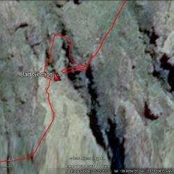 the Camels Back" title="Around the "Bad" section of