
Gray's Pass - Ships Prow Pass Loop
13 Jan 2016 11:46 #66446
by bungykhb
Replied by bungykhb on topic Gray's Pass - Ships Prow Pass Loop
how long did it take you from Injisuthi to the top of Ships Prow Pass?
Please Log in or Create an account to join the conversation.
13 Jan 2016 12:03 #66448
by ingmac
Replied by ingmac on topic Gray's Pass - Ships Prow Pass Loop
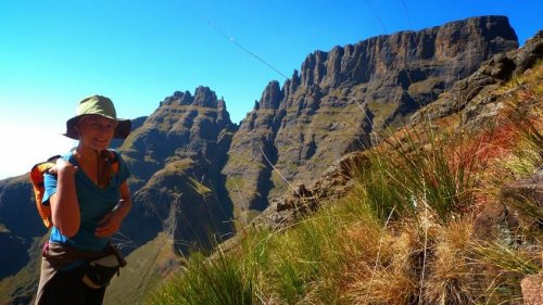
Gosh, you are really asking! The first day we hiked from Injisuthi to Cowl Fork camp, and that took is approximately half a day, starting late morning and arriving early afternoon. The next morning we started around 8am, and arrived at our camp above Ships around 8pm. It was slow going through the scrub (without a panga), and one of our party got bad altitude sickness. We proceeded slowly up the pass as a result. From the bottom of the pass after the scrub to the camp site probably took us 6 hours, give or take.
Please Log in or Create an account to join the conversation.
13 Jan 2016 13:01 #66450
by biomech
Replied by biomech on topic Gray's Pass - Ships Prow Pass Loop
In other words: A PROPER EPIC! 12 hour days in the mountains are hectic!
Please Log in or Create an account to join the conversation.
16 Jul 2017 10:59 #71866
by abrahamvlok
Replied by abrahamvlok on topic Gray's Pass - Ships Prow Pass Loop
Hi!
Its that time of the year when I get to spent some time with some friends in the best place in the universe. If anybody have comments about this (doability/safety/water) then please share with me.
(We are three guys, around 38, with many hikes in the Drakensberg behind us, we have done things like summit a iced Corner Pass at night...so we are not new at this)..nevertheless, none of us have done Grays Pass or Ships Prow. With that being said..here is the plan
* Day 1 : 20 July'17 : hike from Monks Cowl parking to Keith's Bushcamp via Blind Man's corner.
* Day 2 : 21 July'17 : up with Gray's Pass and move as close as possible to the top of Ships Prow.
* Day 3 : 22 July'17 : down with Ships prow and get as close as possible to the contour path back to Blind Man's corner (ideally sleep at Cowl Fork - but that may be a stretch).
Has anybody done this recently ? Do anybody have GPS tracks / waypoints ?
Have a nice day!
Abraham Vlok
Please Log in or Create an account to join the conversation.
- abrahamvlok
-

- Offline
- New Member
-

Less
More
- Posts: 9
- Thank you received: 14
18 Jul 2017 09:58 #71881
by TheRealDave
Replied by TheRealDave on topic Gray's Pass - Ships Prow Pass Loop
Hi Abraham:
I did this route recently (see my hike report here , but see the whole thread, which contains lots of useful info, as well as the other Ship's-Prow threads). I don't have a GPS track, but it's not a route that needs one.
1. The hike to KBC is straightforward. The path is clear the whole way. KBC is right at the top of the valley on the left (true right).
2. The Nkosazana Valley is not long, so you will have a lot of time to spare on Day 2. There are good camping spots below the saddle and I believe there are also good spots on top of Champagne Castle. There is also Nkosazana Cave, but that is at the bottom of the valley near the top of Gray's Pass, and it is sometimes damp.
3. Your goal of Cowl Fork is quite manageable, but please note that it is rocky, bushy, and slanted, so you will have better options further on, where the contour path meets Van Heyningens at the Blind Man's Corner marked on Slinsby's map, or at the official campsite just behind the split to KBC that everyone calls Blind Man's Corner. (I was also aiming for Cowl Fork, but I tried to take a shortcut at the bottom of the Ship's Prow Valley and wasted a lot of time. Avoid this - I describe it in my write-up.) The only flattish areas before Cowl Fork are where the contour path goes round the ridges, but the grass there is thick and clumpy.
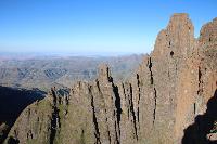
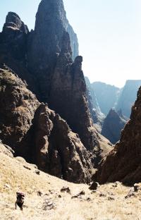
Ship's Prow has a daunting reputation, but I didn't find it much harder than Leslie's going down. The pass itself is well-marked with cairns. In the valley, keep to the true left - there is a path and cairns all the way to the bottom, and only there does it get a bit vague. Here you simply stay in the riverbed, go round the bottom of the last spur, head up the narrow valley, and you will start to see the contour path coming down the hill to the river on your right. There are also good cairns in this section.
Take care and enjoy!
I did this route recently (see my hike report here , but see the whole thread, which contains lots of useful info, as well as the other Ship's-Prow threads). I don't have a GPS track, but it's not a route that needs one.
1. The hike to KBC is straightforward. The path is clear the whole way. KBC is right at the top of the valley on the left (true right).
2. The Nkosazana Valley is not long, so you will have a lot of time to spare on Day 2. There are good camping spots below the saddle and I believe there are also good spots on top of Champagne Castle. There is also Nkosazana Cave, but that is at the bottom of the valley near the top of Gray's Pass, and it is sometimes damp.
3. Your goal of Cowl Fork is quite manageable, but please note that it is rocky, bushy, and slanted, so you will have better options further on, where the contour path meets Van Heyningens at the Blind Man's Corner marked on Slinsby's map, or at the official campsite just behind the split to KBC that everyone calls Blind Man's Corner. (I was also aiming for Cowl Fork, but I tried to take a shortcut at the bottom of the Ship's Prow Valley and wasted a lot of time. Avoid this - I describe it in my write-up.) The only flattish areas before Cowl Fork are where the contour path goes round the ridges, but the grass there is thick and clumpy.
Ship's Prow has a daunting reputation, but I didn't find it much harder than Leslie's going down. The pass itself is well-marked with cairns. In the valley, keep to the true left - there is a path and cairns all the way to the bottom, and only there does it get a bit vague. Here you simply stay in the riverbed, go round the bottom of the last spur, head up the narrow valley, and you will start to see the contour path coming down the hill to the river on your right. There are also good cairns in this section.
Take care and enjoy!
Please Log in or Create an account to join the conversation.
- TheRealDave
-
- Offline
- Elite Member
-

Less
More
- Posts: 195
- Thank you received: 256
20 Sep 2017 17:29 #72174
by jwe
Replied by jwe on topic Gray's Pass - Ships Prow Pass Loop
Did your plan work? ")
Please Log in or Create an account to join the conversation.

23 Mar 2018 15:31 #73044
by swordfish
Replied by swordfish on topic Gray's Pass - Ships Prow Pass Loop
I'm planning to do a circular route Monk's Cowl and back over the Easter weekend spending 2 nights in the mountain. These would be my first 2 night out of a camp site. First night I plan to spend at Keith Bush Camp. Then not sure about the second night. Would it be doable to go up Grey's pass, spend the night somewhere before Ship's Prow pass and back via Ship's Prow on the next day to Monk's Cowl? Or any other suggestions? What would be the water situation between Gray's and Ship's Prow?
Please Log in or Create an account to join the conversation.
23 Mar 2018 15:39 #73045
by Sanet1
Replied by Sanet1 on topic Gray's Pass - Ships Prow Pass Loop
@Swordfish,
There are plenty of spots to sleep over on top of the escarpment if this is your preference. However, should you do so you are in for a fairly long next day as you will have to descend Ships and trek back to camp, which, depending on your fitness level, could take a fair amount of time. With all the rains lately I can just imagine that the bush wacking down Ships's bottom part will take longer than usual.
What I would suggest is to rather go up Grays and down Ships on your second day. We've done this exact same route a couple of years ago with two complete newbies and they made it. Was a loooooong day and we got to the camping spot down Ships about 10 minutes before nightfall (in the river bed pretty much opposite the exit point out of the river, under the large pine tree). This will make for a more leisurely last day. Be sure to know the whereabouts of the Ships riverbed campsites as the riverbed is normally thick with vegetation which makes spotting the campsites more challenging. Tip: the bottom campsite is roughly diagonally across the large pine tree on the true left hand side bank of the river.
Please Log in or Create an account to join the conversation.

23 Mar 2018 15:41 #73046
by Sanet1
Replied by Sanet1 on topic Gray's Pass - Ships Prow Pass Loop
Regarding water - there is a nice stream flowing down from Ships to Grays, never found it dry, even at the end of winter.
Please Log in or Create an account to join the conversation.
23 Mar 2018 15:50 - 23 Mar 2018 22:46 #73048
by swordfish
Replied by swordfish on topic Gray's Pass - Ships Prow Pass Loop
@Sanet1
Thank you very much for the suggestion. Makes more sense to descent Ship's Prow and then camp.
Is there any scrambling involved up Gray's? If I read around correctly, there is no scrambling at all going down the south fork of Ship's Prow pass.
Thank you very much for the suggestion. Makes more sense to descent Ship's Prow and then camp.
Is there any scrambling involved up Gray's? If I read around correctly, there is no scrambling at all going down the south fork of Ship's Prow pass.
Last edit: 23 Mar 2018 22:46 by swordfish.
Please Log in or Create an account to join the conversation.
