
Gray's Pass - Ships Prow Pass Loop
However for this past long weekend, we decided against attempting it. Instead we spend the whole time at Injishuthi doing various day hikes in the area.
Please Log in or Create an account to join the conversation.
Riaang wrote: As Dave mentioned, don't go into that gully. Chat to AdrianT on the forum if you want to find out what the gully is like, he's been partially down it by mistake at night, and he told me that he is not doing that ever again.
Yes definitely don't go into that gulley, not past the turn off onto Grays Pass. Probably a top 3 worst experience being in that bed of marbles at night after a long day. Plus, without rope and some basic trad gear to set an anchor, you can't go down a certain point anyway - that point being about 220 vertical metres down from the start. A giant chock stone with about a 10 metre drop on the other side, judging by throwing stones over, more or less
 The sloping lip meant we could not peer down and the gulley too steep to see further.
EDIT: having also done Ship's I wouldn't take any small children up or down there. My 1 SA cents worth.
Please Log in or Create an account to join the conversation.
I am also planning a hike later in the year using the route you suggested, in other words starting at Keith Bush Camp.
I am not at all familiar with the area. My question is, where do you leave your vehicle if you want to start your hike at Keith Bush Camp?
Please Log in or Create an account to join the conversation.
- HikerParsons
-

- Offline
- Senior Member
-

- Posts: 31
- Thank you received: 7
One can't start at Keith Bush; one starts at Monk's Cowl campsite, ascends the Little Berg via the Sphinx, then contours round Hlathikulu Nek to reach the Mhlwazini Valley. KBC is at the head of that. It's about 14 kms in total. See grab of map below:HikerParsons wrote: I am not at all familiar with the area. My question is, where do you leave your vehicle if you want to start your hike at Keith Bush Camp?
Please login or register to view the image attached to this post.
Please Log in or Create an account to join the conversation.
- TheRealDave
-
- Offline
- Elite Member
-

- Posts: 195
- Thank you received: 256
HikerParsons wrote: My question is, where do you leave your vehicle if you want to start your hike at Keith Bush Camp?
If you use a helicopter, you can leave it at Keith Bush

If you arrive with a car, you leave it at Monk’s Cowl, pay the overnight hiking fees and fill in the register.
Please Log in or Create an account to join the conversation.
I am planning a hike in the middle of June with a bunch of experienced hikers. I would like any comment about water / security and anything else that may help us.. The route will be:
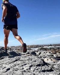
Day 1: Leave Injesuthi and go as close as we can get to Ship's Prow pass and sleep.
Day 2: Summit Ship's Prow and sleep in Nkosasana Cave.
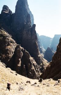
Day 3 : Down Grey's pass, pass Keith's Bush Camp and hike to Cowl Cave and sleep.
Day 4 : Along Shada ridge, down Van Heynigens and back to Injesuthi camp and drive back to Pretoria.
We tried something similar two years ago but started too late and ran out of water on the way to Ships prow pass...so we turned around and had a very relaxing time.
Does anobody know if there is water on top of Grey's pass or on the way to Nkosasana cave ? If I am not mistaken then I hear rumours about safety around Greys' pass a few years ago. Any comment ?
How come the mountains call when it starts freezing in Pretoria ?
Regards!
Mod Note- Post moved to existing thread
Please Log in or Create an account to join the conversation.
- abrahamvlok
-

- Offline
- New Member
-

- Posts: 9
- Thank you received: 14
I've seen Nkosazana Cave damp at this time of year, and it is quite small and low - not sure how big your party is. I can't advise on the water levels up there, but there was a good flow at KBC a month ago. It would be worth getting confirmation, as if the Nkosazana isn't flowing, it could be quite a walk to find water. There are also lots of places to tent at in this valley or (more discreetly and advisably) further up on top of Champagne Castle, though it's high there and can get properly cold at night.
Gray's sees lots of traffic from migrants and smugglers. In my experience, the smugglers keep to themselves, but opportunistic theft has occurred. Theft by Basothos seems to be more of a problem, and I believe there are kraals one valley over. But if no-one knows you're in the cave, then they're unlikely to come looking, unless they themselves wish to use it. As in any area, take precautions.
Day 3 - you're aware that Cowl Cave is at about 3,000 m? So this would be down Gray's then up Cowl Pass - certainly doable, but after an approach to Ship's and an ascent of Ship's, you would need to be pretty fit to do this comfortably in a day. Then there is still the descent of the south side of Cowl Pass the next day, which is not regarded as easy. There are threads on Cowl Pass and Cowl Cave with more info.
Please Log in or Create an account to join the conversation.
- TheRealDave
-
- Offline
- Elite Member
-
- Posts: 195
- Thank you received: 256
Please Log in or Create an account to join the conversation.
- mike_cromberge
-

- Offline
- Junior Member
-

- Posts: 28
- Thank you received: 10
Coming down Grays and then up to Cowl Cave sounds cool.
Heading down from Cowl Cave to the contour path (to get to Shada) could be a long day - it took us an entire day, although we could've moved faster. And that was just from the cave to the contour path. I'd guess to Injisuthi camp is another 3 hours from there. There probably won't be water for the first hour or so as you head down.
- Graeme
Please Log in or Create an account to join the conversation.

Day 1- from MC, Kearlands, H.Nek to KB
Day 2- KB , Up GP, Halfway down the real Cathkin, bivy somewhere amongst bramble
Day 3/4- Continue, either camp at M6 or break the mould and continue back via Cowl fork, Blind, Sphinx, MC
My only tip, and personally the most valuable one. Take the correct pass.
Ship's Prow South, Cathkin North according to No.2 Map.
(The 'rope access' thing is justifiable on Cathkin Pass.)
Please Log in or Create an account to join the conversation.

