- Forum
- Drakensberg Forum
- Drakensberg Grand Traverse
- Grand Traverse Write-ups
- GT2015/2016: Climb every mountain
GT2015/2016: Climb every mountain
07 Jan 2016 22:23 #66355
by ghaznavid
Replied by ghaznavid on topic GT2015/2016: Climb every mountain
GT2015/2016: Climb every mountain (part 3 of 4)
Day 8: Home Ground Advantage (Upper Injisusthi Cave to Durbford Base Camp)
Somewhere between Leslies Pass and Upper Injisuthi Cave, Hobbit had lost both of his water bottles. So we had gone from struggling with 5 between 2 people, to hopefully making a plan that works for 3 between 2 people. This would make the use of caves very difficult going forward.
Leaving Upper Injisuthi Cave, our packs are heavy, but not as heavy as they were at the start. Andrew will be taking a leisurely stroll from here to Didima Cave – “only” about 35km away.
We start by bagging Trojan Wall, not the biggest khulu in the Berg, but it does come 6th on the highest list. We had missed 8th through to 11th due to the hypothermia incident and not detouring through to Red Wall, but we could at least secure the top 7 from here. We just needed the 2 KaNtuba Peaks to do this.
We dropped down the gully between Injisuthi Dome and Trojan Wall to find the highway trail that runs towards Judge Pass. The river was still flowing well, although not as well as it had been a few weeks earlier on my previous GT.
We decided to follow the trail right through to Judge Pass, followed by a quick walk up Judge Peak. I had bagged this khulu before, and it is definitely one of the more worthwhile ones in the area. Actually – come to think of it, even though Giants Castle is full of odd and close khulus, most of them are worth the effort.
We proceeded from here to slog up Popple, funny to bag this peak a fourth time. Years ago I had failed to climb it on 3 tries, now it is really not that difficult to get up. We followed the top of the ridge from here to bag Auditor before dropping down near the escarpment edge. We stayed high, finding water in the small stream that flows between Auditor and Gypaetus Point. We went on to bag Gypaetus Point before taking lunch just south of Bannerman Pass.
We had hoped to bag Sanqebethu, but with lightning around, we gave it a miss. There was a big storm approaching, and a surprisingly prominent khulu above a massive cliff is not usually where you want to be in a thunderstorm!
We detour up Bannerman Face, get a quick summit shot before practically running down off it. Near Thumb Spur it had begun to rain, I could tell it would be a massive storm, so we set up the tent and waited out the storm in it. This turned out to be a good call as we spent well over an hour in the tent.
When it did eventually clear, we both took a walk up Thumb Spur Peak, and had a proper look at the top of Thumb Pass. There is a possible, but exposed and difficult, line that would top out on the other side of the peak. It would be hard to spot from the pass, but may go. As for the south gully route I had my eye on for years – I rate this would go. Now the question is whether or not I should continue to pursue every arbitrary gully at Giants!
We went back to the tent, packed it up, and tagged Langies Pass before taking a low traverse towards Mount Durnford. At the top of Bond Pass, we dropped the packs and shot up Erskine. We then took the packs to the saddle near Bond and Potterill, and tagged these easy khulus as well. We dropped from here to the top of North Jarding Pass (to get an accurate GPS co-ord, which I failed to do last time I was there), before heading back to the packs.
By 7:30PM we had found a good camping spot near (100m away from) flowing water. A long day, but a productive one! That was 10 khulus in a day – my personal record. Not to mention that 9 days earlier, Hobbit’s personal record for a day was 3, incidentally he first did 3 in a day when we did Bond, Potterill and Erskine as a day hike.
Day 9: Going Big (Durbford Base Camp to near Terateng Cave)
If you wish to climb every non-technical khulu, there are some easy ones to pick up, and some difficult ones. I knew this day would be a big one.
The tactic of camping halfway up what I believe to be the hardest ridge on the escarpment (from either side) is one I have used before, and would happily use again. Durnford took about 30 minutes to knock off, and did generate vast amounts of sweat. We tagged all 3 summits, concluding that the middle one is easily highest (consensus visually and by GPS altimeter). We agreed the middle summit should still be in SA, but that a second opinion is required as it depends on what the bottom looks like. Based on my photos from North Jarding Pass, it clearly flows into SA and thus the middle summit is the khulu.
From here we followed the escarpment edge, getting Kambule, finding that Carbineer Point (my textbook example of what is wrong with the original khulu definition) actually has close to 55m prominence – I actually sent Hobbit back down to the saddle to double check this – and we then went onto Katana. I eyed out the top of Katana Pass, or alternatively the fake South Jarding Pass gully, which could be completed by traversing the grass ledge below the peak and then using this summit to top out. While eyeing it out, I noticed a local walking towards our pack, so we headed back to them with great haste.
The river from Long Wall was flowing quite well, lots of animals around, but otherwise no different to how it would normally look in April.
We bagged Long Wall Peak, and I congratulated Hobbit on his completion of all Giants Castle’s khulus (note that Giants Castle Peak and Giants Pass Peak are both at Lotheni, according to the maps). Hobbit found some debris from the crash that happened there a few years back. I am surprised I had never noticed this before, I knew it was the crash site, but I had never paid that much attention before.
We traversed from here to Lotheni Peak – the summit was playing host to plenty of shepherds, forcing us to carry our packs up it. We then followed the spur down into the Hawk/Tent valley – thus at least we cut a big corner by staying high.
This valley always feels very long, and after what felt like a few weeks, we eventually hit flowing water in the valley.
We had lunch, including a hot soup each, before heading towards the mighty Tent to bag the khulu. Nearing the saddle between Hawk and Tent, I noticed 2 locals following us. I decided to take a break and let them catch up to us, rather here than where we will stash our packs. Hobbit’s nose began to bleed, so I walked out to the gentlemen. Their first question was “what witchcraft is this?” – Admittedly I was concerned that they would try to do something funny, but fortunately they didn’t. After a 10 minute chat, and some chips, they left us. By now Hobbit’s nose had stopped bleeding. We walked for another 500m, just to make sure the packs were well out of sight. We found 3 different gullies that appear to go between the 2 peaks – a return trip will be required!
Tent is a big peak, but if you follow the southern watershed line, all cliffs are easy to bypass. Some mist was rolling around when we summited, but nothing major.
From here we returned to our packs, traversed around to the saddle between Hawk and Lithabeneng, and once again stashed packs before bagging this khulu. Once again, we stuck to the southern watershed line and encountered no difficulties. As we hit the top, mist came over, but fortunately we had a great view till right near the top.
We walked past the top of Uklebe Pass – which looks like a serious gully, not the traverse top I was expecting – before having lunch on the stream that flows down from near KaMas Pass. We had supper here.
We knew the valley was heavily inhabited, but we didn’t have enough time to get the entire way over Redi and still bag the khulus, so we decided to shoot for Terateng Cave.
Water bottles filled, and supper sorted, we began up the steep climb towards KaMas Pass. The trail is strong and easy to follow.
Near the top of the pass, we dropped our packs to tag Lithabeneng – a khulu I had not bagged before. We tagged the SA summit, and noticed the much larger Lesotho summit about 100m away. We then heard voices on the highway trail, so we ran back to the packs without bagging the Lesotho Peak. The Lesotho peak looks rather big and blocky, actually really awesome – but one for next time. We counted the khulu as a khulu bagged, after all, Murch ignored Lesotho in his definition. But we both knew that the khulu wouldn’t stay on the list when a better definition is implemented, and we both plan on going back for the Lesotho Peak.
It was already around 7PM, so we had no plans for bagging Terateng this night, it would have to wait for morning. We had a look at the ashy floor of the cave, and soon found a lovely flat spot to camp about 200m away from it. The cave looks great, provided you have about an hour to shovel dirt and you have a good ground cover!
The nearest water was a good 100m vertically below us, so we would have to make do with what we had. Fortunately we were out of sight of the highway trail, and we had a lovely view to wake up to!
Day 10: Going Bigger (Near Terateng Cave to Nhlangeni Base Camp)
We began the day by hauling our packs up above the highway, bagging Terateng, and then going up Redi. We went up both the main Redi summit and the false pointy top nearby. No reason why we “had to” go up both, but for the sake of completeness, we did.
From here we shot up the easy Litseketseke Spur before dropping down into the Hlathimba Valley.
The river on the north side of the valley was completely dry. He had had just over 2 litres of water between the 2 of us since around 6PM the night before, and all 3 bottles were bone dry by now.
Fortunately the river on the far side of the valley was flowing solidly, saving us having to complete another ridge without water. We went up Mlahangubo Peak along the way, before holding the escarpment edge line through the top of the next valley. This line adds a lot of distance and altitude for a view that isn’t particularly amazing – so I do understand why people don’t normally do it – but I had bigger fish to fry. 3024 and 3166m fish to be specific.
We had an early lunch on the escarpment edge. Even when the spot isn’t as spectacular as the top of Leslies or Rwanqa, it is still a good view. Hobbit decided to have oats and pilchards for lunch, so I was a tad suspect. He explained that he didn’t have oats for breakfast due to lack of water, and he had extra pilchards after having the resupply a day early. Seeing as we were on track to comfortably finish a day early, I didn’t stress about this.
We walked around the base of Ntsupenyana, traversing higher as we went, before stashing our packs in the Ntsupenyana/Ngaqamadolo saddle to climb the peak. The peak is usually very far out of the way on a GT, but our line through the valley made it possible. At 3024m, it isn’t very high, but has well over 100m prominence due to how low the surrounding valley is – thus making it quite an effort.
When we returned to our packs, we decided to take them up further so that we could traverse higher around Ngaqamadolo – after all, there is a kraal quite high up on the Lesotho sister peak, so there was likely to be a good trail. This could also easily cut off 2km.
Like we had done on the Hawk and the Tent, we stayed on the watershed line, this time climbing the eastern Arête line. The cliff bands were easily negotiated, but the mountain did take an age to climb. When we got near the top, the large chasm separating the highest point from the ridge we were on began to bother me. Fortunately it can easily be walked around once you are near the top. Lightning was striking around Thabana Ntlenyana, and I could see a lot of rain coming – so we got some photos before racing down. Logically we should have carried our raincoats up, but we hadn’t. We also didn’t cover our packs – Hobbit has a black cover, so no problem there, but mine is bright orange, so I am always concerned that it will attract attention if not well hidden.
We reach our packs as the rain hits. Rain coats and splash covers are on before anything gets wet, so no harm done this time. I look at the time to realise that it took over 2 hours to bag this particular khulu. And that was without packs!
We traverse around as the rain begins to pick up. I was right about the trail, and soon we are nearing around 10 dogs, but the 4 Basothos keep them quite. Once we are around the corner, we drop down to the lower trail.
To my horror, the Mohlesi River is dry! We find water in a side stream, and we decide to stop here for supper. I knew I wanted the big khulus, so I had kept this day short – so this wasn’t a problem.
As we were cooking, it began to rain again. We quickly finished cooking, gulped our food down and soon started walking again. Near the base of Nhlangeni we found a pretty rubbish campsite without much concealment and not that close to flowing water – but Hobbit had had enough, so we set up our camp here. It was raining, but Hobbit and myself have done so many drills on setting up a tent in under 5 minutes that the tent is up in no time.
When I get into the tent, Hobbit finally tells me that he has run out of food. I had kept my extra day of food in reserve, so this wasn’t a massive problem – but I knew that this could result in him not achieving the status of youngest person to complete a GT. After all, the rules require that he carries all his own supplies.
After him showing me everything he had left, I realised that all I needed to give him was a sachet of tuna, a cereal bar, 4 pieces of dried fruit and a packet of chips. 400g at most. But I explained to him that it was possible that he wouldn’t get the record because of this. This clearly upset him, but what can you do?
Day 11: Looking ahead (Nhlangeni Base Camp to Mangaung Pass)
We began the day by slogging up Nhlangeni Peak. Anyone who has seen this peak will know that it is a monster. We followed the southern Escarpment Edge side, getting a great view of King Kong on the way up.
We had had a slow start to the khulu chase, but after missing most of the easy summits at Mnweni and Didima – we were not looking on track for the record. Having bagged almost everything at Giants and Lotheni, and on track to take everything at Vergelegen, Nhlangeni had put us on 52. This meant I had broken my personal record, but we knew we had to bag almost everything from now to the finish if we wanted to take the record.
The last 2 days we hadn’t gone far, and this would be another shortish day – meaning that from Sani to the finish we would have no more reserve days available.
We decided to take a funny line through the Mohlesi region – we were already so far around, so we found a traverse line into Mohlesi Pass. It was a bit exposed, but we hit the pass above a large boulder. It was clearly possible to traverse out on the other side, but we stayed in the gully to the top of the pass. The pass is shown as “may require ropes” on the map, and David Bristow says it shouldn’t be called a pass – but from above it looks like the obstacles can easily be avoided by the grass slopes true right of the pass. I doubt I would even bother staying in the gully if I did the pass.
We topped out, passing a decent looking cave on the slog up to Mohlesi Peak. When we reached the top of the peak, there was a large group of locals with bags giving us the evil eye, so we didn’t tag the saddle, just got quick summit shots and moved on.
We sat in a nearby saddle and found yet another decent looking cave, this one has clearly been used before, with a stone wall outside. It looks like it wasn’t used recently, though, as it was a bit overgrown.
We proceeded to climb the false Sehonghong Peak (which we climbed on purpose, we knew it wasn’t the correct one), and then climbed the actual Sehonghong.
We had lunch in the saddle between Sehonghong and KaNtuba Buttress. The view from this spot is great, and being yet another short day, we had no real urgency to get moving again. I knew the next 3 days would be tough, so I didn’t want to put the pressure on at this point.
We left our packs below KaNtuba Buttress and had a long stop on top of KaNtuba Buttress. It has to be the highest summit where the cairn is within 1m of the escarpment edge – well worth a visit and clearly visible basically from Giants to Mashai. We had cellphone signal for the first time in a week while here (previously Upper Ndumeni Cave), so I got off a few smses, including one to move our pickup plans a day earlier.
With the end now in sight, we went up SA’s 5th highest peak – KaNtuba. For the second year in a row, I bagged this peak on New Years Eve in the rain – although this year included hail as well. When the rain calmed, we took summit shots, before dropping the packs and bagging Manguang (3401m) – a Kgolo in Lesotho (KaNtuba Peak on Peak Bagger). It doesn’t count for the GT khulu record, but that doesn’t make it any less worthwhile.
Looking down at the Phinong Ridge Gap and knowing how close Sani is, it took great restraint to not just make a dash for it. We agreed that we would only reach Sani around 5PM, and would have to stay there for the night. Being New Years Eve, that would mean noise till the early hours, and we needed to keep our focus for the task at hand.
We went back to our packs, and held the escarpment edge on our way down to SA’s Manguang Peak. There are a few gullies around Manguang Pass, they all look like they go from above. Manguang Pass is south of the khulu, I believe the one north is Dykes Pass, but I am not 100% sure.
We camped a bit around from the top of the pass. Once again we set up the tent to avoid the rain, although this time the rain only came an hour after we set up. I sent Hobbit on a 1km walk for water – after the walks I had done for water in the first half of the traverse, I had made up for this by getting him to do all the water collections. The rules require a 50:50 share of all work, including cooking and water collection. Andrew reminded me of this at UIC, so I made sure Hobbit did basically all cooking and water collection from there to the end. Well, that was the excuse I used anyway!
It did eventually rain quite heavily, but we were already in the tent by then, so we didn’t care.
This was New Years Eve, the end of 2015. The morning would bring Sani – we had washed our clothes in the river, cleaned off properly. We were ready to be as presentable as people who have been on a mountain for 12 days could be. I didn’t know the exact stats at the time, but I was ending 2015 on 1227km of hiking in the Berg – shattering my record set a year earlier. Not just shattering it, but over a third of my total Berg distance was in 2015. We both went to sleep knowing tomorrow would be a good day.
We had some “natural fireworks” during the night – a very loud thunderstorm welcomed in the New Year for us that night.
Please Log in or Create an account to join the conversation.

07 Jan 2016 23:06 #66357
by ghaznavid
Replied by ghaznavid on topic GT2015/2016: Climb every mountain
Please login or register to view the images attached to this post.
The following user(s) said Thank You: diverian
Please Log in or Create an account to join the conversation.
07 Jan 2016 23:08 #66358
by ghaznavid
Replied by ghaznavid on topic GT2015/2016: Climb every mountain
Please login or register to view the images attached to this post.
The following user(s) said Thank You: diverian
Please Log in or Create an account to join the conversation.
07 Jan 2016 23:09 #66359
by ghaznavid
Replied by ghaznavid on topic GT2015/2016: Climb every mountain
Please login or register to view the images attached to this post.
Please Log in or Create an account to join the conversation.
07 Jan 2016 23:11 #66360
by ghaznavid
Replied by ghaznavid on topic GT2015/2016: Climb every mountain
Please login or register to view the images attached to this post.
Please Log in or Create an account to join the conversation.
07 Jan 2016 23:13 #66361
by ghaznavid
Replied by ghaznavid on topic GT2015/2016: Climb every mountain
Please login or register to view the images attached to this post.
The following user(s) said Thank You: LouisvV
Please Log in or Create an account to join the conversation.
07 Jan 2016 23:14 #66362
by ghaznavid
Replied by ghaznavid on topic GT2015/2016: Climb every mountain
Please login or register to view the images attached to this post.
The following user(s) said Thank You: diverian, LouisvV, tonymarshall, pfoj, AndrewP, saros, biomech, myriam
Please Log in or Create an account to join the conversation.
08 Jan 2016 21:49 #66373
by ghaznavid
Replied by ghaznavid on topic GT2015/2016: Climb every mountain
GT2015/2016: Climb every mountain (part 4 of 4)
Day 12: Bullets and Thunderbolts (Mangaung Pass to Sandleni Cave)
A 4:30 alarm clock officially welcomed us to the new year. The smell of hot food at Sani was in the air, on this occasion it was easy to get going quickly.
Before Sani, however, there were some khulus to bag. We started by shooting for the peak I refer to as Nshinshinshinshinshini – although it is actually just called Ntshintshini. There are 2 summits for it, we climb both, getting the prominence of each. The higher one is the khulu, with a rather interesting narrow cliffy top and a large spire just below – who says the Southern Berg has no rock climbing peaks?
We proceeded up to Mqatsheni – bagging both the SA summit (which is currently a khulu, although I fear, not for much longer), and proceed to tag the Lesotho high point as well. As we hit the Lesotho summit, it begins to rain.
My GPS says that Sani is 3.6km away, although also roughly 400m vertically below us. Rain coats on, splash covers on, Sani ahead, and march! It was 6:42 when we left Mqatsheni, and we motored it to Sani from there. My GPS track shows a surprisingly straight line once we drop below 3000m, only significantly altering our course upon reaching the outer wall.
We drop our packs inside at 7:30 – we had hoped to be there by 7, as that is when breakfast opens, but fortunately basically everyone is still asleep after the early morning celebrations, so no trouble finding space, and the good food isn’t finished yet.
We must have had 4 full plates of food each, the food was really good and fresh! Thank you Sani Mountain Lodge!
After an hour of eating, I try to hunt down our resupplies. No one seems to know where they are, but the manager will know – when he eventually wakes up. Apparently Brian only got to sleep at 4 that morning.
By 10AM, I am starting to plan alternative arrangements for what we can do if our resupplies aren’t there. Sani to Bushman’s Nek in a day is quite an ask, but if we can get some food from Sani, we can at least hit Mashai Shelter for the night.
Eventually our resupplies are found, and at 10:45 we leave Sani in bright sunshine.
We give Sani Peak a skip (not to be confused with the large unnamed conical summit next to North Hodgeson’s). On our way up towards North Hodgesons we meet a British teacher on holiday from Malawi – we lead him up North Hodgesons as the mist rolls in. On the way up we hear 3 very loud gunshots. Well, they sounded more like surface-to-air-missiles, I have no clue what calibre the gun must have actually been – but I have never heard the round through the air like that before. As much as I know my World War 2 tanks pretty well – the difference between an M4A3E2 and an M4A3E8 isn’t lost on me – I really can’t identify guns by sound. So what it actually was will remain a mystery to me – all I know is that it most certainly wasn’t a SAM! Perhaps the echo in the valley resulted in that particular sound.
Anyway – we dropped our packs, but in the saddle between North Hodgesons and that conical peak behind it, we saw 4 Basothos – not very interested in us though. I was immediately worried about where we left our packs, but when I saw them going for that saddle, I worried less.
We bagged the khulu, due to the mist, the British man decided to skip the south summit as we shot back to our packs. The 4 men had mounted up while we were summiting and were now galloping around and shouting in Sotho to each other. Our packs were fine, although they were very close to them when I got back to them (I actually ran the last 200m).
As we dropped into the valley, I saw some men walking through the valley with large sacks, and there were more gun shots. About 5 shepherds in the valley were scrambling to get animals and were running away from Masubasuba Pass. I realised this was actually quite a bad situation to be in. In the back of my mind, the recent mugging on Masubasuba Pass was also a thought. I decided to follow suite of the shepherds and we walked downstream to a concealed position where we waited for about half an hour.
By this point, my mind was struggling to differentiate gun shots and lightning – I did not want to be in this situation, I wanted to get as far from this valley as soon as possible. When we left, we saw another group coming over the South Hodgesons ridge with large bags, so we soon sat down again to wait for them to pass.
Eventually we set off, found a trail and traversed the ridge. The gap we took was much further inland than the normal gap – I used the gap on the VE GPS track, but my camera stayed firmly packed away. No reason to make people worry about me.
As we neared the saddle, I local was hiding behind some rocks, I asked him if it was ok to keep going, and he said yes. Not sure if he was a look out, but seeing him did admittedly make me jump!
As we dropped towards the Pitsaneng River, I was very happy to not see anyone else around. Lightning picked up as we dropped towards the river, but I kept walking in as straight a line as possible towards Sandleni Cave! Seems this day warranted a lot of straight lines!
It was pouring with rain, lightning crashing all around us – but we were both still full from a big breakfast, so we kept on going. In my mind, Sandleni Cave is the best choice for this night (it was the original plan anyway). The cave faces away from the escarpment and is far from where the action was. At this point I was really wishing I was there.
We reached the cave around 4PM – our earliest finish since Upper Ndumeni Cave. The main cave was mostly soaked, but the tunnel caves looked worse. We found a large dry patch right at the back.
I repaired some of the drainage channels from the prior year, and we set up a clothes line near the entrance. The flow of water at the back of the cave was fast enough to fill a 750ml bottle in about 10 seconds with very fresh, clean and icy cold water. What a luxury that flow is!
It had been a very stressful day, but at least it was over. It cleared up around sunset, the views below were great – and more importantly, Thamathu Pass Peak was visible. What other encouragement does one need!
Day 13: Mist Opportunities (Sandleni Cave to Mzimude Cave)
Day 13 started slowly. There was mist around, but it looked sunny above the cave – so I ended up waiting on top for Hobbit to finish packing up. When he arrived, I reminded him about his splash cover, and he quickly popped back down to get it. So, for the moment, the tally of lost gear is still only 2 water bottles for the trip. He had bought a 500ml Poweraid at Sani, so at least the bottle front was looking a bit better.
We set off across the valley in the mist. Like a year earlier, the Sandleni valley was a large marsh. Probably more from the days of rain than anything else, but I will not complain about too much water during a drought.
We slowly made our way up No Mans Peak in the mist, following the VE GPS track. The mist cleared briefly near the saddle, just enough for us to bag the khulu. The summit cairn has been trashed, but otherwise I could entirely believe that there is a massive dropoff right next to me.
We stopped just below the peak in a patch of sun. Well, it was sunny for the first 20 seconds. From the top of North Mzimukhulu Pass we could switch to the Speed GT track (which had only loaded on my GPS between Bannerman Cave and the finish line due to a system error). I knew I wouldn’t find Verkyker’s summit in the mist without a degree of luck, so we opted for agreeing to do Andre’s Knob instead on the last day. No Mans was our 61st khulu, so 3 more gave us the record – but we knew that Lithabeneng and Mqatsheni would be suspect, and unlike the other suspect khulus on our list, these 2 weren’t on Andrew’s list. We also needed to account for the fact that Ifidi Pass Peak was disallowed in Andrew’s 63 (actually 64 khulus plus 1 kgolo with Ifidi Pass Peak and Thamathu) – so we needed every khulu we could get.
We met some very friendly Basothos near the top of North Mzimkhulu, they walked with us for about 1km before we went our separate ways. They pointed us to the saddle that Andrew’s GPS track pointed to – so we took the easy way over the Verkyker Ridge. We also met a very well dressed man on a horse, probably the chief, or chief’s son, he spoke very good English and couldn’t understand why we didn’t just catch a taxi. He also warned us that it might be dangerous for the 2 of us to hike without anyone else, but I told him I wasn’t worried. He smiled and went off.
The saddle Andrew uses on the speed GT cuts some distance and comes out right near the bottom of the Mlambonja Ridge, so it made sense on this occasion. Our choices were a harder line in the mist with no GPS track, or an easier, shorter line in the sun with a track. The difficult choices we have to make at times…
I had hoped to race through the valley behind Rhino, with all the troubles we had had here in the past. Perhaps it was the massive purple cloud engulfing the high ridge, or maybe our timing was good, but we only encountered 3 very friendly Basothos in this valley on this occasion. None of them even asked for anything.
I gave Hobbit a brief geography lesson on topographic rainfall (which was happening in front of us) and an oxbow lake (which we crossed just after crossing the main river). Always important to pretend that hiking is an educational activity…
As we began to climb Mashai, Hobbit was behaving strangely. He then said he needed to take a walk so he could look for something. I suggested that he should take my GPS in case the nearby mist makes it hard for him to find me again. He spent a good half an hour looking before he returned to me, it turns out that he dropped the fleece I loaned him and couldn’t find it. I was not happy that he went so far to look for it – he had a raincoat, so if it rained he should be ok, but what if he was attacked or injured and I couldn’t see where he was. So after a lecture about looking after gear and not going that far away from me on a trip, we set off up towards the saddle again.
We took a while to get up, but were soon standing on top of yet another peak in the mist. I suspect I could go the entire way from Garden Castle to the top of Mashai in the mist without much difficulty, so doing the last 100m in the mist was easy. Hobbit was looking a tad blue, probably feeling guilty about losing the fleece I had loaded him, so to try and cheer him up we did the supposedly traditional Green Jelly Bear Song chant:
The bear went over the mountain to see what he could see – hey!
The other side of the mountain was all that he could see
So he went back over the mountain to see what he could see – hey!
The other side of the mountain was all that he could see
After about 3 tries, he finally went along with it and was looking much brighter.
From here we tried to stay as close to the escarpment edge as possible. We knew we were still going to struggle to break Andrew’s record, so Mzimude was a must. We took a good break before dropping packs and heading up the khulu. We took a funny scrambly line through the top cliff – let’s call it the western arête, probably about C grade, although very wet on this occasion. We checked the large cairn and the actual summit cairn before taking the easy way down the north face (no scrambling required).
From here we hunted for Mzimude Pass Peak in the mist. We climbed 3 summits before I settled on which one it was. I recognised the Michelin Man rock feature from the prior year, so I knew I had it. Actually I only really knew I had the correct peak the following morning, but let’s just pretend that I was ultra-confident finding a very arb bump in a large valley in thick mist! The summit cairn wasn’t what I remembered, but looking back at my GT2014/2015 photos, it was the same top.
Anyway – as it turns out, my GPS co-ord for Mzimude Cave was gone, and I had no co-ord for the pass gully, so I had to figure out where it was in the mist. Fortunately the mist cleared just enough to spot the cave as I had concluded that a particular gully was not the right one – when in fact it was the correct one.
The water below the cave was flowing slowly, so no water problems for this day.
The mist was so thick that night that we couldn’t see anything outside the entrance to the cave. Not even the cliff literally 5m outside the cave. Easily the thickest mist I have ever been in, and I lived in Hilton for 7 years.
Day 14: Bacon and Cheese (Mzimude Cave to the finish line)
The final day of the GT was here. There was some low cloud, but I could see we were in for a hot day.
We started by getting up to the final saddle of the High Berg Escarpment (well, aside from the top of Thamathu Pass). We dropped the packs and shot up Walkers. The summit of Walkers is actually in Lesotho, so we made a point of bagging the Lesotho summit, and the tiny SA summit with 2m prominence (about 20m apart). Walkers was our 65th, so we had the record if dodgy summits are included. If Ifidi Pass Peak is taken off Andrew’s list, and our 2 dodgy peaks are taken off as well, we were on the record at this point – 63 khulus each. Technically Walkers is a dodgy peak too, but unlike the others, Andrew’s record also included it.
We dropped back to our packs and started down the ridge. Near Isicutula Peak, we dropped below the cliff line on the SA side, using the fissure gully that lines up with Isicutula Pass, Walkers Pass, Sandleni Pass, Dykes Pass and eventually Giants Pass. We traversed from here, and after about half an hour we were standing on Andre’s Knob. How to word that better? We climbed Andre’s Knob? No, that’s worse. Anyway – juvenile jokes aside – we now had the record irrespective of how you classify it. I hoped to beat Andrew’s record by enough of a margin that we would withstand a reclassification of khulus, and hopefully the likes of Tent, Hawk, Ngaqamadolo etc. will have helped with this, but we both knew the haul would be in danger. We returned to our packs before bagging the last freebie khulu – Isicutula.
We dropped down Isicutula Pass quite quickly – stopping for a break near the bottom. Water was flowing well from quite high up on the pass.
From Isicutula Pass to the top of Thamathu Pass is always quite boring, but the smell of cheese sandwiches kept us going well. This was my first time coming down Thamathu Pass (my 4th time on the pass though), so views were different to normal, but with the heat baring down on us, we just kept going.
As we neared Mushroom on Thamathu, Hobbit was looking very flat and had slowed considerably. It turned out that he was out of food and water. I had some food left, but for reasons I can’t explain now, I didn’t offer any to him. I gave him some water, and we were soon off again.
As we hit the river crossings we agreed that it was too hard, we should bail and just head back to Sentinel
As we crossed the last river, my mother (who was collecting us at the finish line) was waiting under a tree.
We tagged the border fence around 1:15PM, meaning that our time was around 13 days and 15 minutes. My mother had brought all the leftovers from Christmas lunch, so we had a good meal before we set off. We then stopped at that place between Silverstreams and Bushman’s Nek Resort (not sure of the name, it has a large sign about paintball outside it) for some cheese toast and chips.
A good hike indeed!
So which is easier, 5 days or 14 days
You would think I would have to think about this, but I really don’t. If you put in the proper training for either, the 5 day GT is far easier – well for me anyway. A light pack and long days vs a heavy pack and slightly shorter days but for almost 3 times as many. The challenges of both differ greatly, and a normal GT does afford you more exploration time. The routes are quite different, and I would propose that the easiest way to go a GT would be over 6-8 days and without a tent (perhaps taking a bivy bag in case you don’t reach your caves).
Records
I sent the info of the assistance I gave to Hobbit (the food and occasional water) along with the submission for the record regarding youngest individual to complete a GT. Dave Gay defined the rules for a youngest GT record, and has confirmed that Hobbit did meet his requirements. So let’s have a round of applause for the new GT FKT, when measured from birth, of 14 years and 332 days.
While I know AndrewP will slaughter our 67 khulu record some time soon, let’s give Hobbit a further round of applause for pulling off that feat. The record was tough for me, and I had done almost 500km of training in the 2 months preceding the GT – including another GT. He had only done 1 overnight hike in the preceding year! I suspect that myself and Hobbit will be the first team where 100% of the khulus were done together by the full GT team on a GT khulu record trip. This record can currently be broken with a degree of concerted effort – I rate up to 80 can be done quite easily on a 14 day GT (if you slaughter the Yodeler’s/Champagne ridge, which none of the 50+ trips did).
I am going to go ahead and define a 3rd record for this trip – in the space of 48 days I went from starting one GT to finishing another (required to be on foot). I assume this too is a record. I am not that worried about having this record for myself, I simply hope that AndrewP will take the bait and break it by doing 2 GTs in a week
I didn’t record most of the track (aside from summits), but generally a khulu adds 1km, and peaks like Ngaqamadolo and Tent most certainly add much more than that. So if we take the standard 230km track, plus the 68 khulus and kgolos we did, that means our GT would be 298km long. During that time I took 1580 photos!
Special thanks go to many people, but especially to:
AndrewP for helping with logistics, the resupply, the 2 Christmas cakes (even though we didn’t get to the first one in time) and encouragement. Your contributions to this GT made it possible!
To my mother for logistical support and the meal at the finish line. Especially the meal at the finish line!
Sani Mountain Lodge and Sani Pass Tours for arranging the second resupply at no cost!
To Hi-Tec SA (and especially Ben) for the gear you provided, you guys are legends! I suspect that those Flash Lite shoes are the first Hi-Tec trail shoes to complete 2 GTs.
To Hobbit for joining me on this rather epic GT and putting up with my barking of orders in the pouring rain!
To Papa Dragon for offering to help with the resupply – even though it didn’t work out like that, your offer allowed us to plan to do something more difficult than what we had at first planned.
To everyone else who encouraged us, who reads this report (or even just looks at the photos) – it is great to know that we don’t hike alone!
In conclusion
As to the question of whether or not I will do another GT any time soon – I suspect I wrote that I wouldn’t roughly a year ago, so who knows. But 3 GTs in 13 months, probably not doing that again! But really – my very long list of Berg goals has been reduced to 3 remaining goals, so perhaps I will calm down in 2016 and just do chilled stuff. Maybe just go for my remaining non-technical khulus as day hikes.
For everyone who hasn’t done a GT, a GT is a really worthwhile hike – if you can’t do the full trip, see if you can make a plan to do it in stages over a few years, but don’t just leave big chunks of the Berg. Every bit of the Berg is special in its own way. There are so many hidden gems that many people will never see.
So 2015 was the year I hiked 1227km in the Berg, bagged my 100th khulu, claimed Kilimanjaro as my 100th time summiting a peak above 3000m, and then followed it up with Potterill as my 200th time summiting a peak above 3000m (a slightly less impressive summit, I would say), the year I did a GT in 107h51, the year in which so many good things happened.
To everyone (anyone?) who actually took the effort to read all 19 pages of this writeup, I hope you enjoyed it! I actually write these long detailed stories for my own records, so if no one actually reads the full story, it really doesn’t worry me.
Anyway – for anyone who doesn’t know The Bear Song (referenced above), here’s a link to the music video. It is entirely arbitrary, but is included here for reference purposes:
Please Log in or Create an account to join the conversation.
08 Jan 2016 22:02 - 09 Jan 2016 08:04 #66374
by andrew r
make a difference. today.
Replied by andrew r on topic GT2015/2016: Climb every mountain
I guess in the next installment we will find out whether or not Hobbit's efforts will be considered eligible for the Youngest GT record in light of his depleted food supply and consequent need to share ghaz's food reserves. And I confess that I have not examined the terms of reference for such record attempts. But I can't see much difference between a scheduled resupply (or 2 or 3), or potentially sharing some Christmas cake left by someone else in Rathole Cave, or buying a meal at Sani Top, or buying something to eat/drink from a Lesotho spaza shop, or drinking water or a cup of tea that may have been carried by your hiking partner, or being given some of your hiking partner's food because your own supplies have run low. I agree that the record-attempter needs to complete the route 'unsupported' but I don't think that means that they should not be allowed do what any other hiker would be reasonably expected to do in similar circumstances.
On to an unrelated question: what is the white stuff on the cairn at Manguang and how did it get there? Whitewash? Bird droppings? Lichen?
Edit: as I was writing this, ghaz was posting the last part of his report... Glad to see good sense prevailed. Well done to both of you for the many achievements logged, and another good read.
make a difference. today.
Last edit: 09 Jan 2016 08:04 by andrew r. Reason: update
Please Log in or Create an account to join the conversation.
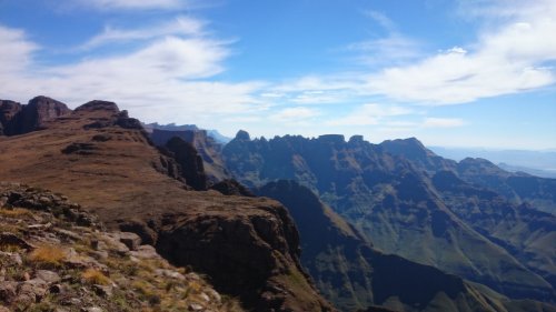
09 Jan 2016 10:39 #66375
by saros
Replied by saros on topic GT2015/2016: Climb every mountain
Well Done Guys!! Very epic write up indeed. Your write ups are always inspiring and interesting!
And a special Congratulations to Hobbit, you go boy!!!!
And a special Congratulations to Hobbit, you go boy!!!!
Please Log in or Create an account to join the conversation.