
Mini Hike Reports
06 Nov 2017 09:54 #72329
by Stijn
Replied by Stijn on topic Mini Hike Reports
Hi Tony - it's a good thing ") Taking a few years off to dedicate to adventure, starting with 7 weeks hiking & mountaineering on NZ South Island, leaving tonight!
Taking a few years off to dedicate to adventure, starting with 7 weeks hiking & mountaineering on NZ South Island, leaving tonight!
The contour path between Judge Pass and Centenary Hut was surprisingly clear and easy to follow. It looked extremely vague in the other direction towards Bannerman Hut though..
Taking a few years off to dedicate to adventure, starting with 7 weeks hiking & mountaineering on NZ South Island, leaving tonight!The contour path between Judge Pass and Centenary Hut was surprisingly clear and easy to follow. It looked extremely vague in the other direction towards Bannerman Hut though..
Please Log in or Create an account to join the conversation.

06 Nov 2017 14:07 #72330
by Riaang
Replied by Riaang on topic Mini Hike Reports
Tony,
Can confirm that the contour path from Judges to Corner pass (i.e to the North) is very clear. You can see it all the way coming down Judges pass, but the actual turnoff from the ridge to the left is a bit vague - however, it is a short distance to hop off the ridge and get onto the contour path, 40m perhaps? This was as of two weekends ago.
The path towards Bannermans hut is entirely non-existent at this point. You would need to go over the ridge/spur directly South of the one you are walking down from Judges, once over this ridge you will pick up the path again on the other side (i.e. further South), the distance being probably about 500m.
The following user(s) said Thank You: tonymarshall
Please Log in or Create an account to join the conversation.

13 Nov 2017 14:34 #72353
by WarrenM
Replied by WarrenM on topic Mini Hike Reports
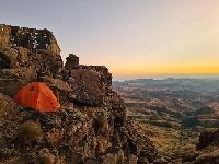
Having not been in the Giant's Castle area, we spent some time there this weekend, on Friday afternoon I went up Giant's Ridge to get my bearings for Saturday, I must say climbing the ridge went quickly and I turned around to head back to camp about 1k from the contour path.
I can't say that I have ever noticed / see and Pink agapanthus before but the flowers in the berg this weekend were really outstanding.
]
Clouds were about and it actually made for some great scenes of the escarpment
I didn't get to see much of the pass as it was it cloud, but at least I got to see where we were headed the next day.
Please login or register to view the images attached to this post.
The following user(s) said Thank You: Andreas
Please Log in or Create an account to join the conversation.

13 Nov 2017 14:54 #72354
by WarrenM
Replied by WarrenM on topic Mini Hike Reports
On Saturday our aim was to ascend Giants Castle, we got up early and started in the dark, it was drizzling but soon stopped, getting to the contour path was fairly straight forward seeing that I had done it the day before.
As we got close to the river that leads up the to the pass, we picked a ridge to climb up to try get to the cliffs to avoid the what we thought were the tougher bits of the pass, with very little visibility we eventually started contouring into the pass (probably to early) found the path and the cairns and started t make our way up.
in the pass, not sure how long it has been there for but there is a carcass in the river.
We gradually made our way up the pass but as you can see from the pic below we could not see very much.
As we got to the top, we started to head up but we contoured right at the same time and eventually found ourselves at the first peak before the greater ridge of Giant's Castle, ironically because of the weather we through it was Giant's Castle, but soon realised it wasn't, I pulled out my Phone and started using Wikiloc to get our bearings and head to the actual Giants Castle, after some fumbling around we got to the Giants Castle, it took is 1h30m of messing around in the mist and cloud to get there, and as I had saved the location of the pass on my watch from Giants Castle we used that to get back to the top of the pass, and ironically in the same conditions only took us 30min as opposed to the 1h.30m it had take us to get to Giant's castle.
Next time I'll remember that as we get out the pass to make a sharp left and head straight up and over, the ironic thing is that there are some cairns around but we would never have seen them.
Around 8 hrs after starting we got back to the camp
Please login or register to view the images attached to this post.
The following user(s) said Thank You: AdrianT
Please Log in or Create an account to join the conversation.
13 Nov 2017 15:20 #72355
by WarrenM
Replied by WarrenM on topic Mini Hike Reports
Sunday was a much better day, and I headed up langalibalele ridge to the pass.
From langalibalele ridge looking at middle ridge, I saw a fairly big herd of Eland, unfortunately the shadow has hidden a lot of them, but it was really great to see so many Eland
the View from the ridge was great
langalibalele Pass was reasonably pleasant and I made it up faster than I had expected
I had this notion in my head that I wanted to get to the Thumb, but when getting there I looked at it and decided that that wasn't going to happen, so I took some Photo's and carried on
I stuck to the escarpment edge the whole way with some great vulture sightings and some fun scrambes as I headed up and past the Bannerman face, and onto Sanqebethu
I had expected a gradual decent from Sanqebethu to the pass but it was actually a lot steeper than I had anticipated with some large rock bands on the left that I had to avoid.
there were two horses in the pass and as I got to the pass I obviously startled them and they, very wisely I must say decided to start running down the pass instead of trying to get out of it. After waiting for them to realise that they needed to be heading out the pass, the slowly made their way onto the grass slops on the side close to the top and I started descending from there.
I had also under anticipated Bannerman pass and the going is really tough as you head down all those bolder.
At the bottom I decided to inspect the Bannerman Hut and I was pleasantly surprised that it is in a fairly good conditions, the flow looked like it had been recently swept, and over all I was impressed.
The contour path and Bannerman Ridge, got hot as it was heading to midday, so it was a walk / run approach for the last 10ks back to the camps.
A very enjoyable loop and back in time for lunch, after 6hrs.
Please login or register to view the images attached to this post.
The following user(s) said Thank You: elinda, Stijn, JonWells, hikingle, tonymarshall, pfoj, AdrianT, saros, Andreas, biomech, TheRealDave, Christinejvr, GriffBaker, Rhinoandhedgehog
Please Log in or Create an account to join the conversation.
29 Dec 2017 21:07 #72528
by hikingle
Replied by hikingle on topic Mini Hike Reports
Last week Friday my husband and I, as well as two of my daughters started our hike from a cold and rainy Giants Castle. This was to be their first overnight hike. The route we had planned was up and down Langalibalele Pass.
We arrived at 9 in the morning but only got going at 11. With two extra people to see to and wanting to make sure their gear wouldn't get wet, we took longer than expected. My youngest (10yrs old) wasn't deterred by the weather at all and couldnt wait to get going.
The rain would stop and then start again. And the clouds would move and reveal a little of the mountains.
Once on the Ridge, it was slow going. I had read that it was strenuous and by now my girls were feeling tired. The constant rain was now taking a toll on them as well. Taking a break up one of the more strenuous inclines.
Walking on level ground was such a relief. And the clouds forming was spectacular! We stopped quite a bit just to watch the 'show'.
It was getting colder and not knowing how far we still needed to go, we set up camp on the Ridge. My husband went down to get water whilst my 16year old and I set up the tent. It was then that they told me they were tired and too exhausted to go on any further the next day. I told them to have something to eat and get a good night sleep and see how they were feeling tomorrow. By 8pm the clouds had disappeared and we were treated to a starry sky. I couldn't remember when last we had seen so many stars! It was breathtaking! The next day we awoke to sunny skies...this lifted their spirits tremendously!
We decided to leave the tent as is, along with the gear and each packed our bags with our valuables and food and started for the base of the Pass.
Collecting water
It took us 2 and half hours to get to the top. The path is clear and well defined and there are cairns at certain places. What started as a sunny hot day quickly changed to cold and cloudy as we neared the top. I was surprised at how cold it had gotten. My fingers were frozen! My two girls were clever enough to bring their beanies and gloves
Looking down...the clouds almost looked like a curtain that was being lowered...thats the best way i can describe it
We made a quick hot drink and walked a few meters in. We saw two horses and lots of cattle. It was too cold to explore any further so we decided to head back down.
I think that we were too busy patting ourselves on the back because instead of taking the lower path back down, we took the higher one and it was only when my daughter pointed out we were moving further from the water below that we realised our mistake. We had found a way to get back to the lower path and had started making our way down some boulders when we heard someone shout. There were 3 Basotho shepherds on horses on the opposite side shouting at us. We didnt understand and after some time one of them got off his horse and came to the edge and started making hand gestures that we need to go back and then go down. By this time we were halfway down and had found the lower correct path. They stood watching us until we were on the correct path and then disappeared into the clouds.
We made our way back down, stopping at the waterfall to fill up our bottles, and just as we reached our tent the clouds started moving in again. Not long after the rain started and continued the whole night.
Please login or register to view the images attached to this post.
Please Log in or Create an account to join the conversation.
29 Dec 2017 21:17 - 30 Dec 2017 05:21 #72529
by hikingle
Replied by hikingle on topic Mini Hike Reports
The next morning when it was time to pack up, the rain had stopped and we started walking back
One of the river crossings
Was thrilled to see these 2 eland
Took this photo just before getting to the chalets
I really enjoyed the hike with my daughters. And was really proud that they didnt give up and most of all they enjoyed it. They have been doing day hikes since they were small. And after this one, they want to do more overnight ones. My 16 year old is already talking about doing Organ Pipes Pass next
Last but not least thankyou to all the members on the VE forum that unselfishly shares all their knowledge, pictures and answering of questions.
Please login or register to view the images attached to this post.
Last edit: 30 Dec 2017 05:21 by hikingle.
The following user(s) said Thank You: elinda, Stijn, Smurfatefrog, AdrianT, Richard Hunt, Andreas, biomech, Christinejvr, Flippie
Please Log in or Create an account to join the conversation.
02 Jan 2018 09:43 #72537
by ghaznavid
Replied by ghaznavid on topic Mini Hike Reports
I'm a bit behind on hike reports, so I'll post a few shots from some of the trips, with a very brief writeup.
On the September long weekend, a team of 3 of us did the Northern High Traverse via the speed GT line (including bagging Mont-Aux-Sources) in 21 hours. We left Sentinel Car Park at 4AM and reached the hotel at 1AM the next morning. Total distance was 65km, and the reason for the slow time can be summed up by the most experienced hiker in the group (the other two don't hike much) having an off day.
Full story at jonathantheghaznavid.wordpress.com/2017/09/28/drakensberg-northern-high-traverse-in-a-day/
Please login or register to view the images attached to this post.
The following user(s) said Thank You: Andreas
Please Log in or Create an account to join the conversation.

02 Jan 2018 10:42 #72538
by ghaznavid
Replied by ghaznavid on topic Mini Hike Reports
3 weeks after doing NHT in a day, I signed up to join an MCSA meet of Giants Cup in a day. Mike and I finished it in 15h58. Unlike the rest of the group, we specifically tagged all 5 huts (Swiman was a pain, as usual, but the hot shower made up for that).
Full story at: jonathantheghaznavid.wordpress.com/2017/10/16/giants-cup-trail-in-a-day/
Full story at: jonathantheghaznavid.wordpress.com/2017/10/16/giants-cup-trail-in-a-day/
Please login or register to view the images attached to this post.
Please Log in or Create an account to join the conversation.
02 Jan 2018 10:44 #72539
by ghaznavid
Replied by ghaznavid on topic Mini Hike Reports
Please login or register to view the images attached to this post.
Please Log in or Create an account to join the conversation.
