
Mini Hike Reports
17 Mar 2020 19:11 - 17 Mar 2020 19:15 #75770
by elinda
Spectacle Cave
Smurfatefrog showing the way
Boots and all - walking up the Gorge
The Gorge
Very much like a mini Tugela Gorge
Replied by elinda on topic Mini Hike Reports
Spectacle Cave
Smurfatefrog showing the way
Boots and all - walking up the Gorge
The Gorge
Very much like a mini Tugela Gorge
Please login or register to view the images attached to this post.
Last edit: 17 Mar 2020 19:15 by elinda. Reason: Additional photo
Please Log in or Create an account to join the conversation.
17 Mar 2020 19:13 #75771
by elinda
Exiting the tunnel
Gorge Cave
Replied by elinda on topic Mini Hike Reports
Exiting the tunnel
Gorge Cave
Please login or register to view the images attached to this post.
The following user(s) said Thank You: Stijn, JonWells, hikingle, Smurfatefrog, tonymarshall, Papa Dragon
Please Log in or Create an account to join the conversation.
17 Mar 2020 19:22 #75772
by Papa Dragon
Replied by Papa Dragon on topic Mini Hike Reports
Very enjoyable hike, ridge route more strenuous than one would think, but oh so worth it.
Gorge exploration also worth it..
Thanks for a good hike, and great pics elinda!!
Gorge exploration also worth it..
Thanks for a good hike, and great pics elinda!!
Please Log in or Create an account to join the conversation.
- Papa Dragon
-

- Offline
- Platinum Member
-

Less
More
- Posts: 763
- Thank you received: 647
18 Mar 2020 11:29 #75774
by Smurfatefrog
Replied by Smurfatefrog on topic Mini Hike Reports
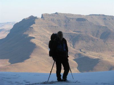
A few pics from me
Masubasuba Pass
Southern Berg from the Hodgson;s south saddle
View from Hodgsons South Peak
Hodgsons South Peak from top of Amakehla Pass
Amakehla Pass
Masubasuba Pass
Southern Berg from the Hodgson;s south saddle
View from Hodgsons South Peak
Hodgsons South Peak from top of Amakehla Pass
Amakehla Pass
Please login or register to view the images attached to this post.
The following user(s) said Thank You: elinda, Stijn, JonWells, ghaznavid, hikingle, tonymarshall, Papa Dragon, Christinejvr
Please Log in or Create an account to join the conversation.
- Smurfatefrog
-

- Offline
- Moderator
-

Less
More
- Posts: 1132
- Thank you received: 1550
19 Mar 2020 09:50 #75777
by Serious tribe
Replied by Serious tribe on topic Mini Hike Reports
Great to see the Amakehla Tarns full, and I have a plan to head out that way hopefully toward the end of the month. That is a very special spot, and I have camped there about three times since 2004. It is though quite a ridge climb to get there, bit well worth it.
Please Log in or Create an account to join the conversation.
- Serious tribe
-

- Offline
- Platinum Member
-
Less
More
- Posts: 1056
- Thank you received: 770
02 Apr 2020 10:08 #75796
by ghaznavid
Replied by ghaznavid on topic Mini Hike Reports
I had 3 Geoseries marked passes left at Southern Vergelegen, so when I had to work from PMB for a week, I decided to head to Sani Backpackers with Dave van der Veen and have a crack at them.
We camped at the backpackers on Friday night (I drove from Gauteng to PMB on Friday - spent a lot of that day driving). My mother joined us to help with logistics.
The Sani Road is tarred as far as the S-bend by the start of the Giants Cup Trail. They had just graded about 1km past this, so at Sunrise on Saturday morning, we started to walk up the Sani road. After about 1km, we managed to flag down a construction vehicle, which took us to the lower border post.
We slogged up the slopes just north of this, heading towards Phinong Pass:
Once we were on top of the ridge, we found a trail leading east, which we took till it joined the Phinong Pass Trail. We then crossed the trail and traversed on the side slopes towards Mqatsheni Pass. This traverse was slow, the trails on the map were hard to find, and the trails we did find generally died after a short distance.
I will write up Mqatsheni Pass on its thread - but I will say it was harder than expected.
We had lunch above the pass, looking at Ntshintshini Pass, our goal for Sunday morning. We also stopped at Ntshintshini Cave, which was very wet. We walked a bit further on the ledge and found a second cave that I had not seen the last time. We both were absolutely stumped as to what the correct line on Ntshintshini Pass would be - but we had come all this way, we would have to give it a proper go.
We started down Manguan Pass. Turns out the pass was harder than anticipated. I had Intrepid's track and writeup, but I didn't expect the top cliff band to be so scrambly. I picked a bad line, which cost time, but we got down eventually.
We reached Kuala Cave just early enough to not need headlamps, around 7PM.
It was full moon and the waterfall was very loud - so neither of us slept very well. About 15 minutes before the alarm went off, we realised we were both awake and decided to start a bit early.
We left the cave just after first light:
We made our way to Ntshinshini Pass. We had a good look at Manguan Pass, the line really isn't obvious:
Heading up Ntshintshini Pass can be read up on its own thread.
We reached the escarpment. A handshake was in order - this pass had defeated both of us before (a few years apart), so it was great to finally complete it.
The traverse to Phinong Pass proved easy enough. Well, I was very tired by this point - but had to keep plodding along.
We found the top of Phinong Pass easily enough and made our way down to the Sani Border Post. I have written up this pass before, no need to write up about it again.
We reached the lower border post around 3PM. After about half an hour of walking on the Sani Road, we managed to flag a bakkie down and get a lift to the Backpackers.
My [brand new] GPS crashed, so my stats aren't as accurate as I would like.
We did roughly 52km in roughly 31 hours. 4 passes, 4 caves (only 1 that we slept in) all in perfect weather. An epic hike indeed!
Please login or register to view the images attached to this post.
Please Log in or Create an account to join the conversation.

05 Apr 2020 15:28 #75800
by Serious tribe
Replied by Serious tribe on topic Mini Hike Reports
That is a serious waterfall coming over the cave! No wonder you slept badly. What was the date of this trip, water in the catchment still looks good?
Please Log in or Create an account to join the conversation.
- Serious tribe
-
- Offline
- Platinum Member
-
Less
More
- Posts: 1056
- Thank you received: 770
06 Apr 2020 08:30 #75801
by ghaznavid
Replied by ghaznavid on topic Mini Hike Reports
7 to 8 March. Water was pretty good on the SA side, but Lesotho seemed abnormally dry for March. We found a bit of water as high as 2800m on the passes.
The following user(s) said Thank You: Serious tribe
Please Log in or Create an account to join the conversation.
15 Aug 2020 11:15 #75930
by Smurfatefrog
Replied by Smurfatefrog on topic Mini Hike Reports
This thread needs a major bump!
With Mnweni open we headed there for the June long weekend, which was some seriously cold weather forecast!
It was -7°C as we passed through Mooi river, and -5°C at our Bergville coffee stop.
We got a lift up the road and set off for Ntonjelana pass, for Easter cave. The final gully was freezing! We topped out just before sunset, chasing the last few rays of "warmth".
Filling up in the river behind Easter cave after sunset with sheets of ice floating in the river was less than fun. At the least the walk up to Easter cave warmed our sore hands a bit.
We were pleasantly surprised that it was much warmer inside Easter cave, so we quickly warmed up once all our warm gear was on. It dropped to about -6°C during the night.
The next morning we headed north to Ledges cave, having to break through ice all along the way to get water.
We were glad to get there well before sunset and tried to catch all the sun we could.
Please login or register to view the images attached to this post.
Please Log in or Create an account to join the conversation.
- Smurfatefrog
-
- Offline
- Moderator
-
Less
More
- Posts: 1132
- Thank you received: 1550
15 Aug 2020 11:16 #75931
by Smurfatefrog
Replied by Smurfatefrog on topic Mini Hike Reports
We tested out ice skating skills on the Orange river, that pool in the little gorge must've had ice of about 1m thick!
The next morning a few of us went for a run around the cutback, before heading down Rockeries pass in the afternoon where we tented.
We then hiked out the next day, this time walking the road section.
The next morning a few of us went for a run around the cutback, before heading down Rockeries pass in the afternoon where we tented.
We then hiked out the next day, this time walking the road section.
Please login or register to view the images attached to this post.
The following user(s) said Thank You: Serious tribe, diverian, JonWells, DeonS, hikingle, Riaang, TheRealDave, HikerParsons, Futch50
Please Log in or Create an account to join the conversation.
- Smurfatefrog
-
- Offline
- Moderator
-
Less
More
- Posts: 1132
- Thank you received: 1550
