
Snow Watch 2016
17 May 2016 09:02 #68482
by AdrianT
Replied by AdrianT on topic Snow Watch 2016
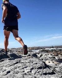
11 May, camping on the back of Cleft Peak. Bit late, I know.
Please login or register to view the image attached to this post.
The following user(s) said Thank You: elinda, JonWells, DeonS, ghaznavid, Smurfatefrog, Redshift3, biomech
Please Log in or Create an account to join the conversation.
19 May 2016 09:55 #68503
by AdrianT
Replied by AdrianT on topic Snow Watch 2016
An hour or so later, also 11 May on top of Cleft Peak, sometimes up to our ankles and a touch over. But within 24 hours 80% of it was gone:
If there was better signal up there it would have been easier to post online
If there was better signal up there it would have been easier to post online
Please Log in or Create an account to join the conversation.
21 May 2016 21:14 #68523
by stefangrab
Replied by stefangrab on topic Snow Watch 2016
Yes indeed, that entire week of 7 to 14th May was very unsettled over the berg (esp Lesotho). I was working first in the Sani Pass region and then Mafadi-Lithotobolong plateau over this period. Some of the snowfalls/grupple (ice rain) was very localized and thin (less than a cm) but because the storm tracks came from the west, there were also some mazing localized snow drifts well over half a meter in depth (see photos).
Light overnight snow 7 to 8 May above ca 3100m in the Sani region.
Heavy snow shower over the Kotisephola peaks regions during mid-morning of 10th May, but had melted by early afternoon.
Late afternoon grupple (ice rain) on 10 May over the entire Sani plateau and mountain areas.
Light overnight snowfall 10 to 11th May in the entire Sani region (and other parts of the berg)...was somewhat heavier above ca 3250m with considerable snowdrift development.
Light overnight (13 to 14 May) grupple and snowfalls over the Mafadi-Lithotobolong plateau, Popple Peak and Giants Castle ranges.
Some of these snowfalls were localized, some melted before they could be captured by the satellite images ...and so it raises interesting questions as to how many localized and lighter snowfalls go unrecorded?
Please login or register to view the images attached to this post.
Please Log in or Create an account to join the conversation.
- stefangrab
-

- Offline
- Senior Member
-

Less
More
- Posts: 30
- Thank you received: 23
22 May 2016 19:23 #68526
by ghaznavid
Replied by ghaznavid on topic Snow Watch 2016
Update: As at this morning (22 May), there are still some patches of snow around Mafadi. Lots of "photo snow" (frost) around in the mornings this weekend.
I didn't get any photos of the snow further inland, but here's an idea of what is left on the south slopes of Injisuthi Dome:
I didn't get any photos of the snow further inland, but here's an idea of what is left on the south slopes of Injisuthi Dome:
Please login or register to view the image attached to this post.
Please Log in or Create an account to join the conversation.

24 May 2016 08:02 #68538
by JonWells
Replied by JonWells on topic Snow Watch 2016
Here is the current forecast for the snow that is expected to fall over Wednesday and Thursday. Forecast amounts vary from around 2 - 7cm, and freezing levels are not expected to drop below 3100m:
Please login or register to view the image attached to this post.
Please Log in or Create an account to join the conversation.

25 May 2016 14:14 #68550
by JonWells
Replied by JonWells on topic Snow Watch 2016
Today's satellite image showing (in red) the isolated snowfall from earlier today beginning at Tiffindell and extending 20km to the North along the high ground:
Please login or register to view the image attached to this post.
The following user(s) said Thank You: saros
Please Log in or Create an account to join the conversation.
26 May 2016 13:38 #68558
by JonWells
Replied by JonWells on topic Snow Watch 2016
Well it seems that the snow only managed to materialise in a very few isolated regions, shown in dark red in the imgage below:
Please login or register to view the image attached to this post.
Please Log in or Create an account to join the conversation.
26 May 2016 14:03 #68559
by ghaznavid
Replied by ghaznavid on topic Snow Watch 2016
I always said that if there is snow on only 1 SA Berg peak, it would be Walkers. Good to know my old saying was right for a change 
Please Log in or Create an account to join the conversation.
11 Jun 2016 08:55 #68758
by tiska
Replied by tiska on topic Snow Watch 2016
11 June
Looks like there is a dusting of snow at Cathedral Peak this morning
Looks like there is a dusting of snow at Cathedral Peak this morning
Please Log in or Create an account to join the conversation.
13 Jun 2016 08:29 #68764
by JonWells
Replied by JonWells on topic Snow Watch 2016
There also seemed to be some light dustings at Tiffindell and on the peaks of the Southern Berg on Saturday morning.
Please Log in or Create an account to join the conversation.
