Snow Watch 2013
28 May 2013 09:32 #57080
by JonWells
Replied by JonWells on topic Snow Watch 2013
Yea I can picture some massive debates happening around whether a picture is showing a 75% or an 80% snowcover 
But yes, I'm not talking about precipitation shadows, obviously snow doesn't fall equally from area to area, but if any specific area has a reasonable amount of snow it will count as a snow event.
Thankfully I doubt there will be too many "marginal" events. We wouldnt even be discussing these types if it wasnt for the Afriski Webcam and and Twitter updates from Sani Lodge etc!
I agree with you about the Cathedral Peak webcam, a single snowflake visible there normally means at least a metre deep layer everywhere else
Please Log in or Create an account to join the conversation.

28 May 2013 10:12 #57081
by intrepid
Take nothing but litter, leave nothing but a cleaner Drakensberg.
Replied by intrepid on topic Snow Watch 2013
Now thats a worthy topic: what constitutes a snow event?
The weakness of using webcams and sat images to qualify an event is that sometimes the cloud cover hangs around too long for a clear shot and by the time it clears the snow is already gone. Also, sometimes the air temperature is such that a worthy snowfall has no chance of living longer than a few hours on the ground. For example, 1cm thick snow on the ground in November or December would be an interesting and worthy event I would think, but you have to be very quick with a camera to catch it.
Media updates from the lodges are great and very helpful, but can also present a skewed perception. I would love to see more consistent reports from the Matatiele/Ongeluksnek area, and from resorts such as Malealea in Lesotho, and at Semonkong. These places represent significant portions of the Maloti-Drakensberg that aren't being covered in the media that I'm aware of.
As for the light snowfall yesterday, I also heard updates of several light snow flurries at Tiffendel. So the snowfall may have been light, but it was widespread. This could be another factor: a quick snow flurry at Tiffendel alone may not qualify, but what if its spread out over a big region like it was?
I think at the very least, there must be snow that settles properly on the ground (grass will always be sticking out), over a wide enough area to qualify, and obviously we need some sort of report or photo to justify it. Where one draws the line in this I'm not totally sure myself currently, but I'd be interested to read more comments on this. It may just have to be a subjective judgement based on the info available. I'd also encourage input from scientific folk like mnt_tiska, who is a geographer and stefangrab, who has written several scientific papers on snowcover in the Berg.
Take nothing but litter, leave nothing but a cleaner Drakensberg.
Please Log in or Create an account to join the conversation.

28 May 2013 12:59 #57082
by tiska
Replied by tiska on topic Snow Watch 2013
Met stations report the usual variables of wind, temp, humidity etc but also report on current weather and the state of the ground.
The following weather codes relate to the reporting of snow at a met station - as defined by the World Met Organisation:
Present weather:
WMO code 4677: Present weather reported from a manned station.
20 - Drizzle (not freezing) or snow grains, not falling as showers, during the
preceding hour but not at the time of observation
21 - Rain (not freezing), not falling as showers, during the preceding hour but
not at the time of observation
22 - Snow, not falling as showers, during the preceding hour but not at the
time of observation
23 - Rain and snow or ice pellets, not falling as showers; during the preceding
hour but not at the time of observation
24 - Freezing drizzle or freezing rain; during the preceding hour but not at the
time of observation
25 - Shower(s) of rain during the preceding hour but not at the time of
observation
26 - Shower(s) of snow, or of rain and snow during the preceding hour but not at
the time of observation
36 - Slight/moderate drifting snow - generally low (below eye level)
37 - Heavy drifting snow - generally low (below eye level)
38 - Slight/moderate blowing snow - generally high (above eye level)
39 - Heavy blowing snow - generally high (above eye level)
68 - Rain or drizzle and snow, slight
69 - Rain or drizzle and snow, moderate or heavy
70 - Intermittent fall of snowflakes, slight at time of ob.
71 - Continuous fall of snowflakes, slight at time of ob.
72 - Intermittent fall of snowflakes, moderate at time of ob.
73 - Continuous fall of snowflakes, moderate at time of ob.
74 - Intermittent fall of snowflakes, heavy at time of ob.
75 - Continuous fall of snowflakes, heavy at time of ob.
77 - Snow grains (with or without fog)
78 - Isolated star-like snow crystals (with or without fog)
79 - Ice pellets
83 - Shower(s) of rain and snow, slight
84 - Shower(s) of rain and snow, moderate or heavy
85 - Snow shower(s), slight
86 - Snow shower(s), moderate or heavy
87 - Shower(s) of snow pellets or small hail, with or without rain or rain and
snow mixed - slight
88 - Shower(s) of snow pellets or small hail, with or without rain or rain and
snow mixed - moderate or heavy
89 - Shower(s) of hail, with or without rain or rain and snow mixed, not
associated with thunder - slight
90 - Shower(s) of hail, with or without rain or rain and snow mixed, not
associated with thunder - moderate or heavy
91 - Slight rain at time of observation - Thunderstorm during the preceding hour
but not at time of observation
92 - Moderate or heavy rain at time of observation - Thunderstorm during the
preceding hour but not at time of observation
93 - Slight snow, or rain and snow mixed or hail at time of observation -
Thunderstorm during the preceding hour but not at time of observation
94 - Moderate or heavy snow, or rain and snow mixed or hail at time of
observation - Thunderstorm during the preceding hour but not at
time of observation
95 - Thunderstorm, slight or moderate, without hail, but with rain and/or snow at
time of observation
96 - Thunderstorm, slight or moderate, with hail at time of ob.
97 - Thunderstorm, heavy, without hail, but with rain and/or snow at time of
observation
The following weather codes relate snow and to the state of the ground:
WMO code 0975: State of ground with snow or measurable ice cover.
0 - ground predominantly covered by ice
1 - compact/wet snow (with or without ice) covering less than 1/2 the ground
2 - compact/wet snow (with or without ice) covering at least 1/2 the ground
3 - even layer of compact or wet snow covering ground completely
4 - uneven layer of compact or wet snow covering ground completely
5 - loose dry snow covering less than 1/2 the ground
6 - loose dry snow covering at least 1/2 the ground (not completely)
7 - even layer of loose dry snow covering ground completely
8 - uneven layer or loose dry snow covering ground completely
9 - snow covering ground completely; deep drifts
Measuring snow is another ball game.
Here's paragraph 1 from a World met Organisation report that is 318 pages long:
The measurement of solid precipitation is recognized as a long standing problem and one that is far more
difficult than the measurement of liquid precipitation. Snow measurement using precipitation gauges has
been shown to have systematic losses of up to 100% caused by wind, wetting and evaporation effects and
depending on the type of precipitation gauge and the observation site. The Commission for Instruments and
Methods of Observation (CIMO) and the Commission for Hydrology (CHy) have been aware of the problem
for many years and as required have appointed rapporteurs or working groups to address specific problems
on the measurement of liquid and solid precipitation.
www.wmo.int/pages/prog/www/reports/WMOtd872.pdf
Please Log in or Create an account to join the conversation.

28 May 2013 13:09 - 28 May 2013 13:12 #57083
by ghaznavid
Replied by ghaznavid on topic Snow Watch 2013
I hadn't thought of that aspect either - distinguishing between soft small hail and actual snow. Or even for that matter, full on massive hail still looks rather similar to snow.
E.g.
Medium sized hail on Hlubi Pass - it looked a lot thicker than this about 30 minutes before the photo was taken
Ugly chunks of ice that were snow a few days beforehand, but still looks like snow
The wonderful soft powdery snow that we will all agree is snow
E.g.
Medium sized hail on Hlubi Pass - it looked a lot thicker than this about 30 minutes before the photo was taken
Ugly chunks of ice that were snow a few days beforehand, but still looks like snow
The wonderful soft powdery snow that we will all agree is snow
Last edit: 28 May 2013 13:12 by ghaznavid.
Please Log in or Create an account to join the conversation.

28 May 2013 13:46 - 28 May 2013 13:49 #57084
by diverian
Replied by diverian on topic Snow Watch 2013
This looked like snow from a distance
But close up was small hail stones
But close up was small hail stones
Please login or register to view the images attached to this post.
Last edit: 28 May 2013 13:49 by diverian.
Please Log in or Create an account to join the conversation.

28 May 2013 13:53 #57085
by ghaznavid
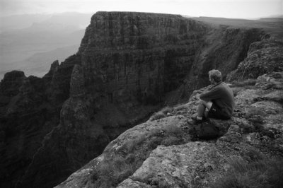
Top of Didima Buttress, right? Took me a while to figure that out.
Replied by ghaznavid on topic Snow Watch 2013
diverian wrote:
Top of Didima Buttress, right? Took me a while to figure that out.
Please Log in or Create an account to join the conversation.
28 May 2013 14:38 #57086
by HFc
Stunning photo BTW !!
Replied by HFc on topic Snow Watch 2013
diverian wrote:
Stunning photo BTW !!
The following user(s) said Thank You: diverian
Please Log in or Create an account to join the conversation.
29 May 2013 06:04 #57087
by diverian
Replied by diverian on topic Snow Watch 2013
@ Ghaz 100 % correct
Please Log in or Create an account to join the conversation.
01 Jun 2013 16:44 #57109
by intrepid
Take nothing but litter, leave nothing but a cleaner Drakensberg.
Replied by intrepid on topic Snow Watch 2013
Seems like the May 27 snowfall did leave something noticeable behind on the sat images. See red patch in the Afriski area on the May 28 image, which wasn't there in the days leading up to it.
Take nothing but litter, leave nothing but a cleaner Drakensberg.
Please login or register to view the image attached to this post.
The following user(s) said Thank You: JonWells, CarlaWesley
Please Log in or Create an account to join the conversation.
04 Jun 2013 06:16 #57132
by Clark
Replied by Clark on topic Snow Watch 2013
Historically speaking, what area of the berg would have the greatest chance of a snowfall? I'm planning a trip for the end of June and want to put myself in the best position to experience snow on the escarpment. I realise there are no guarantees but any suggestions?
Please Log in or Create an account to join the conversation.